"The sun knew not where she had housing;
The moon knew not what Might he had;
The stars knew not where stood their places.
Thus was it ere the earth was fashioned."
Verse from Prose Edda written by Icelandic Law Speaker and poet Snorri Sturluson, c.1200
Located in the middle of the Northeast Atlantic between Greenland and the British Isles, Iceland is the largest volcanic island in the world with an above sea level area of 103,000 sq km. Seafloor spreading at the Mid-Atlantic Ridge, the mid-ocean boundary between the diverging North American and Eurasian plates, gave rise to the elevated basalt plateau via effusive and voluminous volcanism.
Its unique landscape is a culmination of the opposing forces of construction via volcanism and sedimentation and destruction via wind, wave, water and glacial erosion. Working in concert, they have established Iceland as one of the most geologically active and dynamic places on Earth where the intimate architecture of a mid-ocean ridge and its processes can be viewed on land.
Its unique landscape is a culmination of the opposing forces of construction via volcanism and sedimentation and destruction via wind, wave, water and glacial erosion. Working in concert, they have established Iceland as one of the most geologically active and dynamic places on Earth where the intimate architecture of a mid-ocean ridge and its processes can be viewed on land.
 |
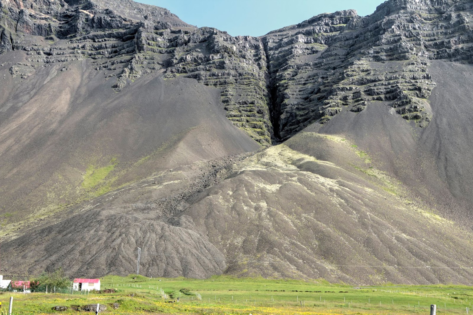
| Eroded Remnants of the Tertiary Basalt Formation in East Iceland The layer-cake morphology of the succession assisted in the construction of Iceland into an elevated basalt plateau. The lava flows of the Tertiary Formation cover well over 50% of the total area of the island. They erupted in volcanic systems on axial rift zones and were carried west and east by divergent tectonic forces that formed the continents of the Atlantic realm across a widening ocean. |
ABOUT THIS POST
It's the third of six on the geology of Iceland and a collaboration with my daughter and travel companion Julia Share. During summer, we traveled around the island on the Ring Road (aka Highway 1 or Þjóðvegur in Icelandic) and F-Roads ('F' is Icelandic for Fjallið' or mountain). The former is a 1,332 km-long, mostly two-lane paved highway, and the latter are gravel-surfaced, often bridgeless, backcountry roads through the remote interior.
• In Part I (here), we explored the geology the Golden Circle triumvirate - world-renowned Þingvellir National Park, Geysir geothermal area and iconic waterfall Gullfoss - and the southwest peninsula of Reykjanes.
• In Part II (here), we investigated Hengill and Hekla Volcanic Systems in the Southwest Highlands and the South Coast's waterfall-populated escarpment across lowlands and glacial outwash plains along the sea. We camped at glorious Þakgil in the South Highlands below ice cap Mýrdalsjökull and in the Skaftafell Wilderness below ice cap Vatnajökull.
Herein, selected definitions are italicized, important names are highlighted in boldface at first mention and global coordinates of various locations are provided, perfect for Google Earth viewing. All photos were taken by my daughter and me.
 |
| Julia on Iceland's Glorious Windswept East Coast |
ICELAND'S ECO-REGIONS
From small but busy Keflavik International Airport on the Reykjanes Peninsula in Southwest Iceland, most visitors head either to the highly advertised Blue Lagoon for a geothermal, silica-soak or go straight to their hotel in Reykjavik and use it as their base of exploration. But, having your own vehicle, high clearance preferably, is enormously liberating, far less expensive than a guide, eliminates back-tracking and allows for far greater exposure to the island's incredible natural features.
As an astronomical bonus, the tilt of the earth's axis conveniently provides extended hours for exploration under the Midnight Sun that peaks in the solstice from May to August. The summer drawback is that Aurora Borealis-seekers won't experience the Northern Lights. It's fair trade with less cold, wind, rain and especially snow that blankets (and hides from view) the geologic landscape.
 |
| Geo-Touring Regions of Iceland Keflavik International Airport on the the Reykjanes Peninsula and nearby capitol of Reykjavik (purple arrow) are in the southwest. The Ring Road (red) essentially follows the coastline, while unpaved F-Roads traverse the rugged, barren and desolate interior. The West Fjords region and Snæfellsnes and Reykjanes peninsulas are off the Ring Road but readily accessible. |
SOUTHEAST GATEWAY TO EAST ICELAND
On our third night, we camped literally in the center of the small fishing village of Höfn in Southeast Iceland (brown arrow). Pronounced somewhere between 'hup', 'hep' and 'hubn', it means 'harbor' in Icelandic. Irish monks settled there before the Vikings arrived in the year 870. For us, it was the perfect stopover before heading north to the majestic East Fjords region on the coast-hugging Ring Road of East Iceland.
The self-proclaimed "Lobster Capital of Iceland" (It's actually a small crustacean called a langoustine) resides on a narrow spit of sand, gravel and boulders where currents meet between Hornafjörður ('Fjord of Horns' named for its curved sandbars) and Skarðsfjörður ('Fjord-Pass leading to village Skarð'). Gouged out of bedrock by long-retreated outlet glaciers (valley glaciers peripheral to a parent ice cap) along Vatnajökull's eastern flank some 3,500 to 5,000 years ago, they're deep estuarial lagoons infused with semi-saline, twice-daily, tidally-driven Atlantic seawater.
 |
| East Campsite View of Vatnajökull across Hornafjörður It's Europe's largest glacier outside the arctic and centerpiece of Vatnajökull National Park, one of three in Iceland and Europe's second largest. Almost 30 outlet glaciers radiate outward in every direction. Lying beneath the ice cap's glacial ice are four massive, active volcanoes. Go there: 64°15'27.53"N, 15°12'4.19"W |
On the modern landscape, the fjords provided Höfn í Hornafirði (the town's official name) with a navigable harbor for its small collection of commercial ships and colorful boats. The fjord has become increasingly shallow from a combination of volcaniclastic sedimentation (derived upland and delivered by rivers and streams), magmatic uplift (espoused by some geologists) and Holocene isostatic uplift (both regionally and island-wide).
The latter is post-glacial rebound of the crust at the rate of about 1 cm/yr or 40 to 170 m, having been relieved of the weight of glacial ice. As a result, Hornafjörður, in particular, has required repeated dredging to maintain it for commerce.
 |
| Working Fishing Vessels in Höfn Harbor Beyond fjord Skarðsfjörður, Tertiary-age central volcanoes tower along the coast stand in sharp contrast to the region's layer-cake, basaltic stratigraphy. Over 20% are comprised of rhyolitic and intermediate igneous rock units that are more evolved compositionally from parent basalts. The red vessel delivered fresh-caught langoustines that morning to the restaurant (unseen) off to the left. Go there: 64°14'59.96"N, 15°12'5.23"W |
CAMPING CITY-STYLE
That's our trusty roof tent-mounted, kitchenette-equipped, high-clearance SUV parked in Camp Höfn. Our spectacular view was of the bulging dome of Vatnajökull to the west, fjord Skarðsfjörður to the north and a misty succession of long-extinct volcanic summits - 'The Horns' - that hug the coast with fjords in between. I must add that every one of our camps was in a locale with incredible views, which is more of a commentary on the island as a whole.
The Höfn region includes an array of small islands, virgin beaches, tidal lagoons, mudflats and marshes and shifting sandbars. The mosaic of wetland features are a haven for seals and some of the world's largest colonies of terns, puffins, ducks, kitiwakes, fulmars, pink-footed geese, great skuas and storm petrel. It's a mecca not only for birds that live, breed and winter there while migrating the Atlantic but birdwatchers that flock there to see them.
 |
| North View of Eastfjord from Camp The campsite resides on the highest point in town on what appears to be an elongated ridge of marine-transported sediment. It was likely built up in the late Pleistocene or early in the Holocene from storm surges, wave-action and currents from nearly eroded cliffs when the landscape had not yet rebounded isostatically and sea level was higher. Go there: 64°15'29.21"N, 15°12'14.77"W |
GOING BACK IN TIME
In many respects, similar to the South Coast, East Iceland has verdant, flat lowlands and volcaniclastic-blanketed sandurs (glacial outwash plains) that lead to the sea. But, a profound change in geology and topography takes place as one drives to the East Coast that intensifies once there the further north one travels. The volcanic bedrock is of the Tertiary Basalt Formation, also curiously found in Northwest Iceland across the island.
The layer cake, bedded succession covers about half the opposite sides of the island and formed some 16 to 3.3. It consists largely of basaltic lavas and interbedded clays, ash and paleosols (strata that eroded and weathered into a soil during quiescent volcanic periods) that were deposited before the onset of glaciation. Its cumulative thickness exceeds 10,000 km but doesn't exceed 3 due to gravitational collapse (outward spreading of the pile).
 |
| Small Exposure of Tertiary Basalt Formation on the South Coast Tertiary basalts typically display vertical feeder dikes that have weathering out in relief. A small talus apron slopes drapes down to a till-blanketed glacial foreland. The uppermost strata has been unroofed by erosion and glaciation. |
ICELAND'S ROCKS BY AGE AND LOCATION
Although the Tertiary lavas emplaced pre-glacially in the warmer climate of the Miocene and Early Pliocene, they were subsequently glaciated in the Pleistocene during some 20 individual episodes or phases (periodic temperature fluctuations triggering glacier advance or retreat). The final
Weichselian episode that lasted from 120,000 to 10,000 years ago is roughly equivalent to North America's Wisconsin episode that blanketed northern North America and Eurasia with well over 1 km of slowly moving ice.
In Iceland, the explosive hydromagmatic interaction of erupting magma and water, whether frozen or liquid, results in a number of distinctive volcaniforms (e.g. table mountains and maars), rock types (e.g. hyaloclastites, zeolites and pillow lavas) and eruption styles (violent Surtseyan and catastrophic jökulhlaup subglacial flooding).
Iceland's bedrock lies on the divergent boundary between the North American and Eurasian tectonic plates. It explains the ages of the flows that possess an E-W symmetry (see map) and the fact that the oldest rocks are at the island's extremes dip a few degrees (5 to 10 on average) toward the country's central axis (or nearest rift zone), while youngest rocks are progressively closer to active rift zones. And, as we are about to see on our journey in the East Fjords region, Pleistocene glaciers have eroded the uppermost parts of the lava piles and carved the lowermost parts into deep, U-shaped valleys and fjords along the coast.
ICELAND'S FOUR MAJOR ROCK UNITS
Iceland's bedrock (above map) is divided into four major units based on age that, as mentioned, become progressively older as one travels west and east away from the central complex of north-south spreading axes, that is, Iceland's volcanic rift zones:
• Tertiary (Miocene-Pliocene) Formation (16 to 3.3 mya) - Iceland's oldest stratigraphic formation at opposite sides of the island, heavily-eroded, largely basalts;
• Plio-Pleistocene Formation (3.3 to 0.7 mya) - on either side of the active rift zones, widespread basalts alternate with subglacial volcanic formations with progressive climatic cooling and total glaciation by 2.2;
• Upper Pleistocene Formation (<0.7 mya) - largely confined to the active volcanic zones as glaciation fluctuated and waned, prominent topographic features;
• Holocene-age (<11,500 mya) - post-glacial sandur deposits and pre/post-historic lava flows.
HEADING NORTH INTO EAST ICELAND
Initially instituted for administrative purposes but effectively repurposed for travel and tourism (and of course geology), Iceland is divided into some eight, nonpolitical regions that not-so coincidentally bear direct relevance to their prevailing geology. East Iceland (Austurland or Austfirðir in Icelandic) is also known as the Eastfjords or simply the East Fjords region, as opposed to the Westfjords in Iceland's far northwest corner.
It's easily the sunniest part of the country with small herds of seldom-seen reindeer, an occasional Arctic fox and recently, thought-to-be extinct wolves around fjord Loðmundarfjörður in the north. Since only 3.2% of Iceland's population of 335,000 live there and with Reykjavik 450 km to the west (too far for a day trip) the region is generally overlooked. As a result, there are dramatically less cars, tour buses, services and crowds that add to the region's allure.
EXHUMED AND ERODED TERTIARY BASALTS
Iceland's 6,000 km-long coastline is varied with fossil sea cliffs, black sand beaches and barren sandurs (glacial outwash plains), but the predominant landform of glacial valleys ending in deep fjords is largely in the Northwest and East region. Before the Ice Age, they were less dissected with inlets and bays formed from rift subsidence and fluvial and marine erosion. Wave-cut basalt sea cliffs such as found along the South Coast (posts I and II) outnumbered sandy beaches and yet-to-form outwash plains.
The post-glacial outcome was a radical alteration of the landscape. At East Iceland, where outlet glaciers exploited pre-existing coastal features that eroded into bedrock such as fluvial ravines, inlets and valleys, they were carved into U-shaped valleys that end in cliff-lined, deep and narrow fjords gouged into the coast's Tertiary basalts. Rather that arising gradually from the seafloor, as the coast does on North America's passive eastern margin, in Iceland, the fjords and in fact the entire coastline rises from a volcanic platform of the identical basaltic magma that built the mid-ocean, elevated plateau.
FEEDING THE FURY
Travelling north on the Ring Road in East Iceland, Tertiary basalts contain countless dikes (vertically and laterally cross-cutting strata), sills (horizontally and laterally between strata) and inclined sheets (angular cross-cutting). They intruded previously bedded lava flows and transported magma to feed surface eruptions of lava that, on the modern landscape, have been exhumed and exposed by erosional loss of overburden and post-glacial crustal rebound.
Formed by a combination of physical (e.g. freeze-thaw cycles) and chemical weathering (e.g. iron-oxidation of susceptible minerals), immense aprons of unconsolidated, eroded talus drape down to meet flat vegetated lowlands. Its tell-tale color is an indication of the volcaniform it eroded from, the mineralogical content of its igneous rock type and the petrological process that formed it. Basically, light is rhyolitic (a felsic rock) and dark basaltic (mafic), although intermediates exist.
VOLCANOES WITH A SPLIT PERSONALITY
Further north along the East Coast, the unmistakable light-colored remains of an inactive rhyolitic central volcano come into view in the distance (photo below). From the Ring Road, we are only getting a glimpse of coastalmost portions of edifices such as Kollumúlaeldstöðvar. Many of their cores are composed of silica-rich, acidic igneous rock and alkaline basalts and intrusions that date back some 5 to 7 million years.
To explain, basalt is a mafic (iron-magnesium containing) extrusive (surface) rock, the most widespread of igneous rocks comprising more than 90% of all volcanic rocks. About 75-80% of Iceland's rocks are basaltic and often found with acidic (felsic) and intermediate rocks from the opposite side and middle of the igneous compositional spectrum (below).
Their 'bimodal' co-existence is a rather unique situation for Iceland's oceanic locale, since rhyolite is the most evolved (chemically differentiated during cooling) volcanic rock, and basalt is the least. How might this association occur?
Some feel Iceland's chemical and mineralological bimodality is related to a sliver of ancient crust buried beneath the island, while others attribute it to fractional crystallization (constituent components form in an orderly progression during cooling) of mafic magma or partial melting (of hydrothermally altered crust forming components with differing composition). See my post Part I for more details.
DEEP THINKING
For decades, Earth scientists have sought to explain various mechanisms for continental drift and the geo-dynamics of long-lived, excessive volcanism at intraplate oceanic plate locales such as Hawaii, intraplate continental locales such as Yellowstone and at Iceland's interplate oceanic locale between two diverging tectonic plates. Two alternative explanations - hypotheses - prevail for Iceland that have profound global implications.
The longstanding core-driven plumal view...
The commonly held view is that the Iceland hotspot (region of volcanism) is the surface manifestation of the INTERACTION of the Icelandic mantle plume and the Mid-Atlantic Ridge.
The former is a mushroom-shaped, fixed (having a stationary base) upwelling diapir (a buoyantly ascending hot but solid rock). It's thought to contain a head and tail and to originate at great depth from the Earth's mantle or even deeper from the core-mantle boundary. The Mid-Atlantic Ridge is a curvi-linear ~16,000 km-long, NS-trending mid-ocean volcanic spreading center that lies between the diverging tectonic plates of North America and Eurasia.
The meeting or juncture of the two played a significant role in (short version):
• the complex Cretaceous-Paleogene break-up of the Boreal (northern) portion of the late Paleozoic supercontinent of Pangaea;
• preceded by extensive and episodic activity that produced Large Igneous Provinces (LIP) of episodic, effusive outpourings of basalt;
• the subsequent opening of the Northeast Atlantic in the Mesozoic-Cenozoic between the nascent continents of North America and Eurasia;
• and, the generation of effusive and voluminous magma that dynamically uplifted and constructed the elevated basalt province of Iceland in the Neogene, some 2 km above the Atlantic seafloor. Iceland is the only active portion of the LIP that is inactively preserved as eroded remnants on the borders of continents of the Northeast Atlantic realm (e.g. Palisades of New Jersey and Giant's Causeway of Ireland).
The plumeless, recycled-remelted crust hypothesis...
A more recent explanation for the formation of Iceland (and rifting, continental break-up, ocean spreading, etc.) that is rapidly gaining ground is plumeless and even refutes its existence.
Proponents adhere that enhanced melt production (at a "melting anomaly") and surface volcanism (at meltspots) are the consequence of far-field forces of large-scale lithospheric extension rather than regional "hot upwellings from great depth driven by a second mode of convection independent of plate tectonics." (Foulger and Anderson, 2005).
To be more specific, Iceland lies where the Mid-Atlantic Ridge crosses the western frontal thrust of the ~400 myo Caledonian suture. It's the plate boundary that formed in the Early Silurian when pre-Pangaean micro-continents Laurentia, Baltica and Avalonia collided as the intervening Iapetus Ocean closed. Melt production may be explained by enhanced fertility (rich in rock-forming minerals) inherited from the ancient, subducted Iapetic oceanic crustal slab that remains in the shallow mantle beneath Iceland, while extraneous slab remnants lie beneath Greenland, Baltica and Britain.
TWO INDEPENDENT VIEWS OF ONE MANTLE PROCESS
'Plumists' consider the event to be a coincidence rather than a primary genetic necessity for Iceland to form. They embrace Plate Tectonics but have appended the concept of a world of plumes to the hypothesis. 'Platists' view the event as consistent with the near-universally accepted concept of Plate Tectonics and not an "ad hoc" addition. It espouses that Iceland was "permitted" or "allowed" to form rather than having been actively induced to do so via an upwelling plume.
Who's right? Paradigm shift in the making? Time will tell. Need more details? Of course you do! Please visit my posts (here) and (here) and the Mantleplumes community site (here).
WHAT'S DOWN THERE?
In spite of what we do know, our understanding of mantle behavior, composition, structure and degree of magma mixing is incomplete. The same exists for the generation of Icelandic magmas. They are thought to have originated potentially from three different sources:
(1) upper mantle components and a geochemically-enriched end-member such as a mantle plume;
(2) a more mineralogically-depleted end member from a Mid-Ocean Ridge Basalt (MORB) from the upper mantle or a second more depleted plume component; and/or
(3) oxygen depleted hydrothermally altered Icelandic crust.
Again, see my previous posts for explanations. Back to East Iceland!
EXHUMED MAGMA CHAMBERS OF ANCIENT VOLCANOES
Further north along the coast, the Ring Road makes dramatic swings around one fjord after another that penetrate deeply into the coast. Erosion and time have removed much of the region's extrusive volcanic rock and left bare the deeper, exhumed intrusive cores of three volcanoes in succession along the coast - Viðborðsfjall, Vesturhorn (Vestrahorn or 'West Horn') and Austurhorn (Eystrahorn or 'East Horn') - that emplaced at a depth of 2-3 km below the surface.
The plutonic roots (exhumed magma reservoirs) of these long-extinct glaciated Miocene-age volcanoes with their misty summits in the clouds make a spectacular backdrop in this remote, exquisitely beautiful and less traveled region of Iceland.

DIKES GALORE
The landscape from fjord Berufjörður in the north to Álftafjörður in the south is rife with glacially exposed, closely spaced, diabase mafic dikes that vertically intrude the stack of westward-dipping Tertiary Basalt lava flows that intuded. The dykes (British spelling) are the main magma feeders in volcanic eruptions, along with sills and inclined sheeted dikes. Their cumulative volume is significant and is a measurement of the degree of spreading that has occurred due to crustal rifting across Iceland.
An overpressurized, likely shallow magma reservoir probably only a few km in depth is fed by a much larger and deeper magma reservoir. It promoted the intrusion of radial dikes and inclined sheets into basaltic host rock under pressure by exploiting weaknesses in the brittle crust, although it is likely that magma-driven fractures can also facilitate their propagation under extreme pressure. Magma buoyancy and topographic load are additional factors that influence dike propagation.
FEEDER DYNAMICS
Following injection, magma, insulated by the confining host rock, slowly cools and solidifies within the feeder system, which may or may not have successfully transported magma to the surface (~75% don't). At the surface, lava is extruded through vents to fissure-flows across the landscape.
Within the host rock, the result is a tabular body with chilled margins that displays as an elongate rock wall once exhumed. The thin dike loses heat horizontally to the host rock and, as a result, doesn't form vertically oriented columns as it does in lava flows, where heat is gradually lost primarily in a vertically up and down direction.
EXHUMED AND SHAPED BY EROSION AND TIME
The eternal forces of geology, erosion and time, working in concert, have exhumed the dikes that persist on the surficial landscape owing to their high density and more erosion-resistant basaltic composition compared to the basalt of the host rock. Little, if any, metamorphic alteration of the surrounding rock occurs, although a distinctive finer-grained, glassy chilled margin and baked zone forms at the interface with the cold host rock.
If the dikes likely emplaced at a depth of 1.3-1.5 km as is thought, imagine the sheer volume of unroofing across the landscape that has occurred over time in order to exhume them. It's the same emotion of astonishment I experience at the Grand Canyon, not just from its enormous magnitude and depth, but the astounding volume of earthen material that's been erosionally removed skyward. I tell everyone that visits the Grand Canyon to not look down but look up!
Many dikes extend out to sea as a skerry (a small rocky island) or are submerged, visible at low tide or not at all. Most dikes in the region are NNW-striking with the trend of the once-active volcanic system from which they are associated. Being part of a massive, radiating dike swarm, they typically decline in numbers with distance from the shallow, still-buried magma body that fed them.
Given enough time, many reach the surface and can be identified on the coastal drive north. Worth a visit, the houses of the tiny, scenic town of Djúpivogur (64°39'21.71"N, 14°17'26.95"W) are actually built among and in between the dikes that serve as protection from the wind and weather.
"DIKE CITY" OF ALFTAFJÖRDUR
With a density of ~10-20%, the dikes along the north side of fjord Berufjörður are in the uncountable hundreds if not thousands (best estimate: 450 to 1,500). The swarm is likely related by proximity to central volcano Altafjordur that formed some 10-12 Ma in the Miocene.
Built by the dikes, the basaltic lava pile dips some 6 to 8º to the west and originally emplaced at a crustal depth of about 0.5 to 1.2 km below the initial depth of the lava pile prior to mainly glacial and post-glacial isostatic exhumation. Many such dikes in East Iceland have a length/thickness aspect-ratio close to 1000 and have been mapped along strike for over 20 km.
DIKE DYNAMICS
There exists a gradual stiffness with crustal depth (expressed by Young's modulus that defines elastic deformation). Along with stress induced by a deep-seated magma reservoir that feeds the swarm, the tensile strain within a rift zone from plate movement and mechanical anisotropy (discontinuities such as joints and weak interlayers), it helps to explain dike propagation dynamics such as frequency and arrest at shallow depth.
That said, dike frequency increases with proximity to the axis of the parent magmatic system. Joints in the dike intrusions form as the magma shrinks during cooling and solidification. Associated with central volcanoes, they're typically 5-15 km-wide and and over 50 km-long and represent the roots of once-active fissure swarms that fed lava flows on the surface within active rift zones, although only about 25% reach the surface where they are expressed as fissures, faults and other extensional structures.
AQUACULTURE
Further north around the big bend from the village of Djúpivogur, floating on the tidally-infused waters of fjord Berufjörður is a collection of open-net fish farms for raising salmon and Arctic char comes into view. The circular pens are suspended in the water and attached to the fjord seafloor and afford predator protection while infusing the farms with marine nutrients and circulating currents that remove waste.
Fish farming is a multi-billion dollar, burgeoning industry on both land and sea, if you include mainland Europe, especially Norway that owns the farming enterprises in Iceland. Currently, a five-fold increase is in the works for a development in the Westfjord region in Iceland's northwest. It's controversial for many reasons.
WILD-CAUGHT VERSUS GENETICALLY-ENGINEERED
An issue globally, the use of open-net fish farms has been a topic of intense debate in Iceland in particular. It's because the fish are genetically-modified via transgene transfer (exogenous DNA sequences introduced into the genome of another organism) and selectively bred from parents with beneficial traits that are chosen to reproduce.
The process claims to confer disease resistance, fillet quality and faster rate of growth. But, ecological concerns include the spread of food-borne pesticides, sea lice (parasites that make them vulnerable to infection) and the genetic pollution of natural stock. The latter has potentially devastating consequences if engineered salmon escape during storms or from predator damage, which they have done on occasion.

If so, it is argued that each of Iceland's rivers has a unique and special stock that has adapted to the environment that differs in the timing of migration, length of time in the sea and how fish negotiate rivers and waterfalls in order to spawn. Introducing farmed-DNA to the natural gene pool might cause their extinction based on survival incapabilities.
"FIRE AND ICE"
Throughout the glacial periods of the latest Pliocene and Pleistocene, the Iceland Ice sheet covered much if not all of Iceland, perhaps with the exception of a few tall coastal mountains, and extended offshore on its currently submerged, volcanic shelves. Some 2,000 m-thick, it was part of a massive glacial system that at one time blanketed the northern regions of Eurasia and North America.
The last glaciation Weichselian episode in Iceland culminated in the Last Glacial Maximum that terminated some 14,500 years ago, give or take. Since then, with multiple periods of starts, stops and reversals (such as the 1,300 year-long, rapid and abrupt cooling period of the Younger Dryas ~around 12,000 years ago), with pervasive climatic warming the ice sheet began retreating to its current extent by ~8ka.
Confined to higher elevations and regions of high precipitation, some 11% of the island possesses five or six clusters of 267 named glaciers (dwindling Ok glacier recently lost its glacial status). They include outlet, surge, cirque, valley-types, etc. and are all remnants of the once-massive Ice Age ice sheet, with Vatnajökull the largest remnant at 8%.
Isostatic unloading and rebound of the lithosphere during and following glaciation across large parts of the island has strongly influenced geothermal and volcanic activity within the complex of volcanically active rift zones. And, Iceland being a region of intense tectonics and volcanism, the affects of glaciation are found throughout the island.
A CLASSIC EXHUMED AND ERODED CENTRAL VOLCANO
On the north side of fjord Berufjörður, the rugged and pinnacled glaciated peaks of Breiðdalur
In Iceland, the explosive hydromagmatic interaction of erupting magma and water, whether frozen or liquid, results in a number of distinctive volcaniforms (e.g. table mountains and maars), rock types (e.g. hyaloclastites, zeolites and pillow lavas) and eruption styles (violent Surtseyan and catastrophic jökulhlaup subglacial flooding).
 |
| Geologic Bedrock Map of Iceland NS-trending rift zones of volcanoes (solid red line) and EW-trending interconnecting seismic/earthquake fracture zones (dotted red) form a slanted, reverse 'h'-shaped structural complex that has been evolving since Iceland began to form. Crustal divergence away from rift zones sent bedrock on a conveyor-belt tectonic journey to opposite sides of the island - the same forces that fragmented supercontinent Pangaea and opened the Atlantic between the diverging North American and Eurasian tectonic plates. Modified from Hallgrímsdóttir. |
Iceland's bedrock lies on the divergent boundary between the North American and Eurasian tectonic plates. It explains the ages of the flows that possess an E-W symmetry (see map) and the fact that the oldest rocks are at the island's extremes dip a few degrees (5 to 10 on average) toward the country's central axis (or nearest rift zone), while youngest rocks are progressively closer to active rift zones. And, as we are about to see on our journey in the East Fjords region, Pleistocene glaciers have eroded the uppermost parts of the lava piles and carved the lowermost parts into deep, U-shaped valleys and fjords along the coast.
ICELAND'S FOUR MAJOR ROCK UNITS
Iceland's bedrock (above map) is divided into four major units based on age that, as mentioned, become progressively older as one travels west and east away from the central complex of north-south spreading axes, that is, Iceland's volcanic rift zones:
• Tertiary (Miocene-Pliocene) Formation (16 to 3.3 mya) - Iceland's oldest stratigraphic formation at opposite sides of the island, heavily-eroded, largely basalts;
• Plio-Pleistocene Formation (3.3 to 0.7 mya) - on either side of the active rift zones, widespread basalts alternate with subglacial volcanic formations with progressive climatic cooling and total glaciation by 2.2;
• Upper Pleistocene Formation (<0.7 mya) - largely confined to the active volcanic zones as glaciation fluctuated and waned, prominent topographic features;
• Holocene-age (<11,500 mya) - post-glacial sandur deposits and pre/post-historic lava flows.
 |
| Heavily-Eroded Tertiary Basalts of the East Fjords Region Cut by Dikes The original landscape looks very different that it does today with majestic central volcanoes, some as high as 1,000 m that towered over broad, flat-lying lava plains. Erosion, Ice Age glaciation and time have provided an excellent cross-sectional view through the Tertiary succession, one that is not available on the modern landscape. Go there: 64°17'18.37"N, 15° 8'41.22"W |
HEADING NORTH INTO EAST ICELAND
Initially instituted for administrative purposes but effectively repurposed for travel and tourism (and of course geology), Iceland is divided into some eight, nonpolitical regions that not-so coincidentally bear direct relevance to their prevailing geology. East Iceland (Austurland or Austfirðir in Icelandic) is also known as the Eastfjords or simply the East Fjords region, as opposed to the Westfjords in Iceland's far northwest corner.
It's easily the sunniest part of the country with small herds of seldom-seen reindeer, an occasional Arctic fox and recently, thought-to-be extinct wolves around fjord Loðmundarfjörður in the north. Since only 3.2% of Iceland's population of 335,000 live there and with Reykjavik 450 km to the west (too far for a day trip) the region is generally overlooked. As a result, there are dramatically less cars, tour buses, services and crowds that add to the region's allure.
 |
| Oblique View of East Iceland's Fjordal Anatomy Facing North Our geo-journey of East Iceland began at the small fishing village of Höfn, on a spit of land on the Southeast Coast between fjords Hornafjörður and Skarðsfjörður. We traveled north on the Ring Road (yellow) in and out of fjords and past "The Horns' volcanic peaks. Heading west just north of fjord Berufjörður, we crossed the sandurs and lava fields of the Northeast Highlands in the direction of Mývatn and the Krafla Volcanic System. Google Earth image. |
EXHUMED AND ERODED TERTIARY BASALTS
Iceland's 6,000 km-long coastline is varied with fossil sea cliffs, black sand beaches and barren sandurs (glacial outwash plains), but the predominant landform of glacial valleys ending in deep fjords is largely in the Northwest and East region. Before the Ice Age, they were less dissected with inlets and bays formed from rift subsidence and fluvial and marine erosion. Wave-cut basalt sea cliffs such as found along the South Coast (posts I and II) outnumbered sandy beaches and yet-to-form outwash plains.
The post-glacial outcome was a radical alteration of the landscape. At East Iceland, where outlet glaciers exploited pre-existing coastal features that eroded into bedrock such as fluvial ravines, inlets and valleys, they were carved into U-shaped valleys that end in cliff-lined, deep and narrow fjords gouged into the coast's Tertiary basalts. Rather that arising gradually from the seafloor, as the coast does on North America's passive eastern margin, in Iceland, the fjords and in fact the entire coastline rises from a volcanic platform of the identical basaltic magma that built the mid-ocean, elevated plateau.
 |
| Undeniable Signatures of Glaciation It left an indelible mark on the landscape with pyramidal horns, jagged spires, thin arete ridges, bowl-shaped cirques, hanging valleys and tarn lakes at higher elevations. Closer to the sea are glacially striated bedrock, depositional moraines, drumlins and kames, unsorted till, glacial dropstones, erratics, and sweeping U-shaped glacial valleys that end in long and deep fjords gouged below the sea and flooded by the tides. |
FEEDING THE FURY
Travelling north on the Ring Road in East Iceland, Tertiary basalts contain countless dikes (vertically and laterally cross-cutting strata), sills (horizontally and laterally between strata) and inclined sheets (angular cross-cutting). They intruded previously bedded lava flows and transported magma to feed surface eruptions of lava that, on the modern landscape, have been exhumed and exposed by erosional loss of overburden and post-glacial crustal rebound.
Formed by a combination of physical (e.g. freeze-thaw cycles) and chemical weathering (e.g. iron-oxidation of susceptible minerals), immense aprons of unconsolidated, eroded talus drape down to meet flat vegetated lowlands. Its tell-tale color is an indication of the volcaniform it eroded from, the mineralogical content of its igneous rock type and the petrological process that formed it. Basically, light is rhyolitic (a felsic rock) and dark basaltic (mafic), although intermediates exist.
 |
| Talus Aprons in the Shadow of Slaufrudalur Pluton's Easternmost Flank Steep-walled Tertiary basalt flows cling to the East Coast and the Ring Road. In this region is located Iceland's largest exhumed, extinct granitic pluton where cauldron subsidence led to Slaufrudalur's roof fracturing and subsequent exposure. End-stage weathered basalt forms soils such as smectite clays. The control of climate on the rate of silicate mineral weathering and thus the burial of atmospheric CO2 in carbonate minerals over geologic time provides a negative feedback stabilizing changes in Earth's atmospheric CO2 concentration. |
VOLCANOES WITH A SPLIT PERSONALITY
Further north along the East Coast, the unmistakable light-colored remains of an inactive rhyolitic central volcano come into view in the distance (photo below). From the Ring Road, we are only getting a glimpse of coastalmost portions of edifices such as Kollumúlaeldstöðvar. Many of their cores are composed of silica-rich, acidic igneous rock and alkaline basalts and intrusions that date back some 5 to 7 million years.
To explain, basalt is a mafic (iron-magnesium containing) extrusive (surface) rock, the most widespread of igneous rocks comprising more than 90% of all volcanic rocks. About 75-80% of Iceland's rocks are basaltic and often found with acidic (felsic) and intermediate rocks from the opposite side and middle of the igneous compositional spectrum (below).
 |
| Compositional and Property Spectrum of Igneous Rocks Igneous rocks are classified by their chemical and mineralogical composition that form when parent molten magmas cool and crystallize. Felsic rocks, light in color and acidic, are iron, quartz, feldspar and silica-rich versus dark-colored, more fluid mafic rocks that are silica-poor but rich in magnesium, olivines, pyroxenes and others. Intermediates lie in between. Each rock category has extrusive and intrusive varieties. |
Their 'bimodal' co-existence is a rather unique situation for Iceland's oceanic locale, since rhyolite is the most evolved (chemically differentiated during cooling) volcanic rock, and basalt is the least. How might this association occur?
Some feel Iceland's chemical and mineralological bimodality is related to a sliver of ancient crust buried beneath the island, while others attribute it to fractional crystallization (constituent components form in an orderly progression during cooling) of mafic magma or partial melting (of hydrothermally altered crust forming components with differing composition). See my post Part I for more details.
 |
| 'Glacial River' Jökulsá í Lóni emptying into Lonsvik Bay The pinkish hills in this region are indicative of rhyolitic volcanism. They constitute 5 to 10% of all igneous rocks in Iceland. The subject of intense debate, they are thought to have originated either from the fractionation of parental basaltic magmas or or during partial mixing of older, metamorphosed oceanic crust. We're on the East Coast just north of Höfn, where the Ring Road crosses a braided glacial river that flows from the east side of Vatnajökull empties into the sea. Dangerous floods are frequent here, especially from large glacial summer melts. The increasingly popular hiking mountain wilderness region Lónsöræfi is in the uplands. |
DEEP THINKING
For decades, Earth scientists have sought to explain various mechanisms for continental drift and the geo-dynamics of long-lived, excessive volcanism at intraplate oceanic plate locales such as Hawaii, intraplate continental locales such as Yellowstone and at Iceland's interplate oceanic locale between two diverging tectonic plates. Two alternative explanations - hypotheses - prevail for Iceland that have profound global implications.
The longstanding core-driven plumal view...
The commonly held view is that the Iceland hotspot (region of volcanism) is the surface manifestation of the INTERACTION of the Icelandic mantle plume and the Mid-Atlantic Ridge.
The former is a mushroom-shaped, fixed (having a stationary base) upwelling diapir (a buoyantly ascending hot but solid rock). It's thought to contain a head and tail and to originate at great depth from the Earth's mantle or even deeper from the core-mantle boundary. The Mid-Atlantic Ridge is a curvi-linear ~16,000 km-long, NS-trending mid-ocean volcanic spreading center that lies between the diverging tectonic plates of North America and Eurasia.
 |
| A Schematic World of Mantle Plumes Rising from the Deep Mantle The arrow indicates the location of the Icelandic plume in the Northeast Atlantic. Its interaction with the Mid-Atlantic Ridge is thought by most to actively drive extension and in so doing form Iceland. Modified from Coltice, 2018. |
The meeting or juncture of the two played a significant role in (short version):
• the complex Cretaceous-Paleogene break-up of the Boreal (northern) portion of the late Paleozoic supercontinent of Pangaea;
• preceded by extensive and episodic activity that produced Large Igneous Provinces (LIP) of episodic, effusive outpourings of basalt;
• the subsequent opening of the Northeast Atlantic in the Mesozoic-Cenozoic between the nascent continents of North America and Eurasia;
• and, the generation of effusive and voluminous magma that dynamically uplifted and constructed the elevated basalt province of Iceland in the Neogene, some 2 km above the Atlantic seafloor. Iceland is the only active portion of the LIP that is inactively preserved as eroded remnants on the borders of continents of the Northeast Atlantic realm (e.g. Palisades of New Jersey and Giant's Causeway of Ireland).
 |
| Two Diametrically Opposed Views of Icelandic Mantle Dynamics Plume or extension driven break-up and Iceland construction? Image by Doctor Jack |
The plumeless, recycled-remelted crust hypothesis...
A more recent explanation for the formation of Iceland (and rifting, continental break-up, ocean spreading, etc.) that is rapidly gaining ground is plumeless and even refutes its existence.
Proponents adhere that enhanced melt production (at a "melting anomaly") and surface volcanism (at meltspots) are the consequence of far-field forces of large-scale lithospheric extension rather than regional "hot upwellings from great depth driven by a second mode of convection independent of plate tectonics." (Foulger and Anderson, 2005).
To be more specific, Iceland lies where the Mid-Atlantic Ridge crosses the western frontal thrust of the ~400 myo Caledonian suture. It's the plate boundary that formed in the Early Silurian when pre-Pangaean micro-continents Laurentia, Baltica and Avalonia collided as the intervening Iapetus Ocean closed. Melt production may be explained by enhanced fertility (rich in rock-forming minerals) inherited from the ancient, subducted Iapetic oceanic crustal slab that remains in the shallow mantle beneath Iceland, while extraneous slab remnants lie beneath Greenland, Baltica and Britain.
 |
| Closure of the Iapetus Ocean and Northeast Atlantic Bathymetry A, The geochemistry, melt volumes and lack of elevated source temperatures of basalts at Iceland are explained by extensive melting of subducted and then recycled/remelted Iapetus Ocean crust trapped in the Caledonian suture that is retained locally in the upper mantle beneath the Mid-Atlantic ridge. Arrows indicate lines of Laurentia, Baltica and Avalonia convergence as slabs subducted beneath Greenland, Baltica and Britain. Thick red line is the inferred opening of the Mid-Atlantic Ridge. B, Shows Greenland-Iceland-Faeroe (dotted) bathymetric ridge (the hotspot track of Plumists), the Mid-Atlantic Ridge (purple) and the inferred trend of the ancient suture (thick lines). Modified from Foulger, Natland and Anderson, 2014. |
TWO INDEPENDENT VIEWS OF ONE MANTLE PROCESS
'Plumists' consider the event to be a coincidence rather than a primary genetic necessity for Iceland to form. They embrace Plate Tectonics but have appended the concept of a world of plumes to the hypothesis. 'Platists' view the event as consistent with the near-universally accepted concept of Plate Tectonics and not an "ad hoc" addition. It espouses that Iceland was "permitted" or "allowed" to form rather than having been actively induced to do so via an upwelling plume.
Who's right? Paradigm shift in the making? Time will tell. Need more details? Of course you do! Please visit my posts (here) and (here) and the Mantleplumes community site (here).
WHAT'S DOWN THERE?
In spite of what we do know, our understanding of mantle behavior, composition, structure and degree of magma mixing is incomplete. The same exists for the generation of Icelandic magmas. They are thought to have originated potentially from three different sources:
(1) upper mantle components and a geochemically-enriched end-member such as a mantle plume;
(2) a more mineralogically-depleted end member from a Mid-Ocean Ridge Basalt (MORB) from the upper mantle or a second more depleted plume component; and/or
(3) oxygen depleted hydrothermally altered Icelandic crust.
Again, see my previous posts for explanations. Back to East Iceland!
 |
| What's Down There? |
EXHUMED MAGMA CHAMBERS OF ANCIENT VOLCANOES
Further north along the coast, the Ring Road makes dramatic swings around one fjord after another that penetrate deeply into the coast. Erosion and time have removed much of the region's extrusive volcanic rock and left bare the deeper, exhumed intrusive cores of three volcanoes in succession along the coast - Viðborðsfjall, Vesturhorn (Vestrahorn or 'West Horn') and Austurhorn (Eystrahorn or 'East Horn') - that emplaced at a depth of 2-3 km below the surface.
The plutonic roots (exhumed magma reservoirs) of these long-extinct glaciated Miocene-age volcanoes with their misty summits in the clouds make a spectacular backdrop in this remote, exquisitely beautiful and less traveled region of Iceland.
 |
| Jökulsá í Lóni at Low Tide Facing South The wide braided glacial river flows from the east side of ice cap Vatnajökull and drains Pliocene and Pleistocene age rhyolitic hills to the west. The Lón area is becoming popular for access to dozens of trails that penetrate the interior with geological rewards such as geothermal baths, remote swatches of forest (a rarity in Iceland that was once forest-covered), lava arches, caves, ice-clad volcanoes and cliffs draped with countless waterfalls. Go there: 64°24'10.25"N, 14°52'59.88"W |
TRAVELLING BACK IN TIME
Austurhorn is the basaltic magma chamber that fueled many of the region's Tertiary volcanoes and the basaltic and rhyolitic lavas and pyroclastic flows. Partially exhumed by erosion, time and Ice Age glaciation, a portion of its 6.5 myo inactive chamber that towers 606 m-high is visible from the Ring Road. To the northwest, the pluton is composed of many smaller intrusions of mafic through felsic rocks.
Its bimodality reveals the complex molten-solid, geo-chemical interactions that occurs beneath central volcanoes in Iceland. About 10-13% of the rocks exposed at the surface of Iceland are silicic that makes Iceland home to the greatest known concentration of the igneous rock in the modern ocean. Its abundance and uniqueness in the geologic record, coupled with the unusual thickness of the island, hints at early continental nucleation processes and crust construction in an oceanic setting.
 |
| Portion of Austurhorn Extinct Magma Chamber It's 'horn' is barely visible in the clouds. The pluton is composed of many smaller bimodal intrusions of mafic and felsic composition. The color of the rocks in the talus streams hints at both the youthful age of the slide and its rhyolitic minerological composition. Here and there, rhyolitic dikes that are far outnumbered by dark basaltic ones are distinguished by their lighter and generally reddish color. Go there: 64°24'20.34"N, 14°32'33.47"W |
WHAT A SIGHT!
Massive aprons of talus drape from cloud-cloaked, glacier-chiseled volcanic remnants that reach the sea filled with uncountable numbers of elegant Whopper Swans (Cygnus cygnus) bobbing up and down. They're mainly a winter visitor to the UK and one of the larger swan species that breed in Iceland, northern Scandinavia and Russia.

With an incredible volcanic backdrop, the allure is overwhelming. Magnificent landscapes. Majestic vistas. Extreme solitude. The sound of waves breaking and the wind. Secluded beauty. Birds everywhere. It's impossible to leave. Whether everyone knows it or not, it's geology that brings them to this place!
 |
| Mountain Krossanesfjall of the Austurhorn Pluton The colors of the mountain's talus - light-colored felsic and dark colored-mafic- are indicative of the igneous rock composition of the parent intrusions. The glaciated roof of the pluton resides atop the edifice. Notice the Ring Road and bird-strewn black sand beach. Rock slides and road closures are frequent here. Go there: 64°24'57.49"N, 14°32'6.68"W |
READING THE ROCKS
The westward inclination of the Tertiary Basalt succession represents the broad flank of a double-sided syncline (downward stratal fold) that tilts in the direction of the now-inactive, nearest volcanic rift zone that fed the vents that fed the flows. Thus, on the landscape, older successions with distance that flank a rift zone gently dip toward the parent volcanic rift zone, whether active or inactive.
 |
Schematic Cross-Section of Crust in Active Rift Zone Loading by volcanism depresses the crust in the zone bending the strata of lava flows downward. A shallow axially-directed, V-shaped syncline forms as successions of lava steeply emanate from the center with a dip of 5 to 10°that shallows with distance. The tilt of the rock pile essentially is preserved as it is tectonically transported conveyor-belt fashion away from the volcanic zone of origin. Arrows indicate direction of ascending magma. Diagram by Doctor Jack |
Successive surges of lava that solidified before the next wave participated in the building of Iceland. Across fjords, flows are concordant (corresponding with the planes of adjacent or underlying strata), having been sliced in two by long-gone Ice Age outlet glaciers that have retreated far upvalley. Reading the rocks and knowing Iceland's tectonic and structural history is geologically empowering and enriches one's travels through this challenging-to-interpret volcanic island.
 |
| Hamarsfjordur Fjord at Low Tide The westward-dipping, Tertiary lavas typically form a massive syncline with eastward-dipping lavas across the rift zone responsible for their effusive generation. The succession is inundated with countless subparallel basalt dikes that stand out in relief. Most dikes abruptly taper or arrest before reaching the surface. Others, that meet fractures and contacts between flows such as weak scoria, ash or redbeds, become offset laterally or vertically. Dike-induced joints or faults appear to have occurred superior to the terminus. Go there: 64°38'42.24"N, 14°24'55.09"W |
DIKES GALORE
The landscape from fjord Berufjörður in the north to Álftafjörður in the south is rife with glacially exposed, closely spaced, diabase mafic dikes that vertically intrude the stack of westward-dipping Tertiary Basalt lava flows that intuded. The dykes (British spelling) are the main magma feeders in volcanic eruptions, along with sills and inclined sheeted dikes. Their cumulative volume is significant and is a measurement of the degree of spreading that has occurred due to crustal rifting across Iceland.
An overpressurized, likely shallow magma reservoir probably only a few km in depth is fed by a much larger and deeper magma reservoir. It promoted the intrusion of radial dikes and inclined sheets into basaltic host rock under pressure by exploiting weaknesses in the brittle crust, although it is likely that magma-driven fractures can also facilitate their propagation under extreme pressure. Magma buoyancy and topographic load are additional factors that influence dike propagation.
 |
| Exhumed Tertiary-Age Dike The near-vertical orientation is actually subtly inclined in the direction of the entire lava pile toward the once-active volcanic zone. Significant lateral migration is quite evident, as is horizontal contraction of the cooling mass of buried magma and primitive columnar jointing, a consequence of cooling and contraction. The dike continues up the talus slope and disappears beneath and beyond it. Go there: 64°39'59.98"N, 14°19'4.74"W |
FEEDER DYNAMICS
Following injection, magma, insulated by the confining host rock, slowly cools and solidifies within the feeder system, which may or may not have successfully transported magma to the surface (~75% don't). At the surface, lava is extruded through vents to fissure-flows across the landscape.
Within the host rock, the result is a tabular body with chilled margins that displays as an elongate rock wall once exhumed. The thin dike loses heat horizontally to the host rock and, as a result, doesn't form vertically oriented columns as it does in lava flows, where heat is gradually lost primarily in a vertically up and down direction.
 |
| Schematic of Internal Architecture of an Idealized Central Volcano and its Dike Swarms The plumbing system includes inclined sheets (centrally-dipping swarm) that radiate outward from a shallow reservoir and dikes that radiate laterally from a deep reservoir in the lower crust. Although poorly understood, sills form when dikes or sheets are deflected along contacts along discontinuities between dissimilar rock layers. Laccoliths develop from sills, are composed largely of acid (felsic) rock and often serve as a shallow reservoir. Fissures are the surface expression of feeder dikes. Modified from Gudmundsson |
EXHUMED AND SHAPED BY EROSION AND TIME
The eternal forces of geology, erosion and time, working in concert, have exhumed the dikes that persist on the surficial landscape owing to their high density and more erosion-resistant basaltic composition compared to the basalt of the host rock. Little, if any, metamorphic alteration of the surrounding rock occurs, although a distinctive finer-grained, glassy chilled margin and baked zone forms at the interface with the cold host rock.
If the dikes likely emplaced at a depth of 1.3-1.5 km as is thought, imagine the sheer volume of unroofing across the landscape that has occurred over time in order to exhume them. It's the same emotion of astonishment I experience at the Grand Canyon, not just from its enormous magnitude and depth, but the astounding volume of earthen material that's been erosionally removed skyward. I tell everyone that visits the Grand Canyon to not look down but look up!
 |
| Julia rides a Lichen-Coated, Exhumed Tertiary-Age Dike Amygdales filled with quartz or calcite and mineral veins are generated via the flow of geothermal water through the dike. Go there: 64°37'34.47"N, 14°25'46.34"W |
Many dikes extend out to sea as a skerry (a small rocky island) or are submerged, visible at low tide or not at all. Most dikes in the region are NNW-striking with the trend of the once-active volcanic system from which they are associated. Being part of a massive, radiating dike swarm, they typically decline in numbers with distance from the shallow, still-buried magma body that fed them.
Given enough time, many reach the surface and can be identified on the coastal drive north. Worth a visit, the houses of the tiny, scenic town of Djúpivogur (64°39'21.71"N, 14°17'26.95"W) are actually built among and in between the dikes that serve as protection from the wind and weather.
 |
| A Myriad of Colorful Succulents and Lichens thrive on the Dike |
"DIKE CITY" OF ALFTAFJÖRDUR
With a density of ~10-20%, the dikes along the north side of fjord Berufjörður are in the uncountable hundreds if not thousands (best estimate: 450 to 1,500). The swarm is likely related by proximity to central volcano Altafjordur that formed some 10-12 Ma in the Miocene.
Built by the dikes, the basaltic lava pile dips some 6 to 8º to the west and originally emplaced at a crustal depth of about 0.5 to 1.2 km below the initial depth of the lava pile prior to mainly glacial and post-glacial isostatic exhumation. Many such dikes in East Iceland have a length/thickness aspect-ratio close to 1000 and have been mapped along strike for over 20 km.
 |
| Feeder Dike Swarm on the North Coast of Berufjörður Both vertical and inclined sheeted dikes represent the roots of fissure swarms that were once active like those seen in active rift zones on the surface. Each swarm consists of hundreds of dikes that increase in thickness with depth. They display the characteristic horizontal joint structure of cooling basalt perpendicular to the the cooling surface. The anatomical exposure of the extinct dike system is a product of Pleistocene glaciation. Again, notice westward tilt of the succession. Go there: 64°45'28.02"N, 14°25'41.22"W |
DIKE DYNAMICS
There exists a gradual stiffness with crustal depth (expressed by Young's modulus that defines elastic deformation). Along with stress induced by a deep-seated magma reservoir that feeds the swarm, the tensile strain within a rift zone from plate movement and mechanical anisotropy (discontinuities such as joints and weak interlayers), it helps to explain dike propagation dynamics such as frequency and arrest at shallow depth.
That said, dike frequency increases with proximity to the axis of the parent magmatic system. Joints in the dike intrusions form as the magma shrinks during cooling and solidification. Associated with central volcanoes, they're typically 5-15 km-wide and and over 50 km-long and represent the roots of once-active fissure swarms that fed lava flows on the surface within active rift zones, although only about 25% reach the surface where they are expressed as fissures, faults and other extensional structures.
 |
| Lateral Extent of the Alftafjördur Micoene Volcano At fjord Berufjörður, the Altafjordur dike swarm (arrow) was exposed by an outlet glacier of Vatnajökull near the end of the Pleistocene. To the northwest are the southern extent of two Miocene volcanoes Thingmuli and Breiddalur. Modified from Gudmundsson, 2014. |
AQUACULTURE
Further north around the big bend from the village of Djúpivogur, floating on the tidally-infused waters of fjord Berufjörður is a collection of open-net fish farms for raising salmon and Arctic char comes into view. The circular pens are suspended in the water and attached to the fjord seafloor and afford predator protection while infusing the farms with marine nutrients and circulating currents that remove waste.
Fish farming is a multi-billion dollar, burgeoning industry on both land and sea, if you include mainland Europe, especially Norway that owns the farming enterprises in Iceland. Currently, a five-fold increase is in the works for a development in the Westfjord region in Iceland's northwest. It's controversial for many reasons.
 |
| Fish Farm in Berufjörður Fjord of East Iceland Go there: 64°45'28.02"N, 14°25'41.22"W |
WILD-CAUGHT VERSUS GENETICALLY-ENGINEERED
An issue globally, the use of open-net fish farms has been a topic of intense debate in Iceland in particular. It's because the fish are genetically-modified via transgene transfer (exogenous DNA sequences introduced into the genome of another organism) and selectively bred from parents with beneficial traits that are chosen to reproduce.
The process claims to confer disease resistance, fillet quality and faster rate of growth. But, ecological concerns include the spread of food-borne pesticides, sea lice (parasites that make them vulnerable to infection) and the genetic pollution of natural stock. The latter has potentially devastating consequences if engineered salmon escape during storms or from predator damage, which they have done on occasion.

If so, it is argued that each of Iceland's rivers has a unique and special stock that has adapted to the environment that differs in the timing of migration, length of time in the sea and how fish negotiate rivers and waterfalls in order to spawn. Introducing farmed-DNA to the natural gene pool might cause their extinction based on survival incapabilities.
"FIRE AND ICE"
Throughout the glacial periods of the latest Pliocene and Pleistocene, the Iceland Ice sheet covered much if not all of Iceland, perhaps with the exception of a few tall coastal mountains, and extended offshore on its currently submerged, volcanic shelves. Some 2,000 m-thick, it was part of a massive glacial system that at one time blanketed the northern regions of Eurasia and North America.
The last glaciation Weichselian episode in Iceland culminated in the Last Glacial Maximum that terminated some 14,500 years ago, give or take. Since then, with multiple periods of starts, stops and reversals (such as the 1,300 year-long, rapid and abrupt cooling period of the Younger Dryas ~around 12,000 years ago), with pervasive climatic warming the ice sheet began retreating to its current extent by ~8ka.
 |
| Modeled Iceland Ice Sheet at Last Glacial Maximum Modified from Hubbard et al, 2007 |
Confined to higher elevations and regions of high precipitation, some 11% of the island possesses five or six clusters of 267 named glaciers (dwindling Ok glacier recently lost its glacial status). They include outlet, surge, cirque, valley-types, etc. and are all remnants of the once-massive Ice Age ice sheet, with Vatnajökull the largest remnant at 8%.
Isostatic unloading and rebound of the lithosphere during and following glaciation across large parts of the island has strongly influenced geothermal and volcanic activity within the complex of volcanically active rift zones. And, Iceland being a region of intense tectonics and volcanism, the affects of glaciation are found throughout the island.
A CLASSIC EXHUMED AND ERODED CENTRAL VOLCANO
On the north side of fjord Berufjörður, the rugged and pinnacled glaciated peaks of Breiðdalur
represent the erosional remnants of rhyolitic lavas and intrusive plugs on the flank of the 9 myo central volcano. It's the full spectrum of igneous rocks that runs the compositional gamut from extrusive rhyolite to basalt, constructed during the Miocene before the onset of glaciation. Following exhumation, Ice Age glaciers ravaged the erosion-susceptible summit.
The volcano's Tertiary age lavas consist of basalt's three-fold subdivisions:
• tholeiites - generally flow-banded in appearance, the most common eruptive rock (50%) associated with submarine eruptions in oceanic crust and mid-oceanic ridges.
• olivine-basalts - common extrusive rock especially in shield volcanoes, though formed by partial melting of mantle rock or fractional crystallization.
• porphyritic basalts - thick flows over large areas from magma chamber's rising magmas, contain phenocrysts (large crystals often of feldspar).
 |
| Heavily Glaciated Summit along Fjord and Central Volcano Breiðdalur The core of the Tertiary age, central stratovolcano is comprised of a profusion of rocks from the entire igneous spectrum and includes pyroclastics. Largely flood basalts built and buried it into the shape of a steep cedar-tree. Subsequent erosion exhumed it and Ice Age outlet glaciers carved it into a classic alpine landscape and gouged its neighboring fjord into a trough that extends below sea level. And, it's all visible from the Ring Road. Go there: 64°47'34.88"N, 14°27'31.84"W |
THE NORTHEAST HIGHLANDS
Pushing onward still on the Ring Road with the goal of reaching the Mývatn lake district and the Krafla Volcanic System by nightfall, we departed from the coastal splendors of East Iceland. Turning inland to the west at the cove town of Breiðdalsvík, we then headed north and west again outside the bustling river town of Egilsstaðir.
With increasing distance from the coast, we entered a younger, more subdued, yet more extreme geological terrain. Our route from fjord to highland transitioned from Miocene through Holocene volcanic bedrock, going forward in time geologically some 16 million years as the landscape became more barren with less changes in relief.
 |
| A Little Color on the Lava Plain of the Northeast Highlands Heading inland from the Tertiary-age successions and volcanoes of the East Coast, the landscape assumes a more expansive and subdued attitude, although numerous volcanic mountains and ranges lie on strike with the axial spreading centers that spurned them. |
BARREN AND BEAUTIFUL
The drive west crosses an exquisite landscape of gently rolling sandurs and windswept lava fields of the Northeast Highlands. It's a stark, vegetation minimalist terrain with big sky, fabulous clouds and only a few travelers on the move. It's a humbling experience to stand in solitude in such an expanse, as Julia felt obligated to demonstrate (below).
The Ring Road is paved, surprisingly well-maintained and open all-year given its remoteness, but don't be deceived for the weather here is highly changeable. In this unpopulated and potentially treacherous area of Iceland, low clouds, dense fog, high winds, sandstorms and snow, even in summer, can occur. Winter drivers especially need to be prepared, well equipped and backcountry-experienced.
 |
| Where's Julia? She's the tiny white dot in the center of the photo. |
A VOLCANIC DESERT OF EXTREME SOLITUDE
Iceland has over 20,000 sq km of deserts that total about 20% of the island. In the highlands, much of the floor is a dense desert pavement. It's a fragile surface of tightly-packed, windswept-sorted and redistributed basaltic rocks and pebbles interspersed with porous tephra and other crystalline materials. In the Northeast Highlands, it originated in shield volcanoes to the south and lies on a succession of deserted lava flows that emplaced in the Miocene, Pliocene and Early Pleistocene.
Although a considerable distance to the south, we're in the rain shadow of Vatnajökull. As a result, the region is arid with permeable lava fields that are subjected to intense eolian processes. The soil is classified as a lag deposit, sorted and concentrated by the physical action of the wind that, along with minimal precipitation that quickly infiltrates into the soil, accounts for the sparse vegetation restricted to species-rich varieties.
 |
| Upper and Lower Pliocene Volcanic Desert of the Central Highlands It's a starkly beautiful, gently undulating, hummocky surface bordered by lowly tuff mountains (consolidated ash from explosion fragmented magma) that lie on NS strike with the active North Volcanic rift to the west, our destination for the evening. |
ICELAND'S "NATIONAL MOUNTAIN"
One dominant summit that comes into view across the barren landscape to the southwest is Herðubreið meaning 'shoulder wide' in Icelandic. Located in the southern portion of the North Volcanic Zone, it towers above the surrounding terrain at 1,683 meters and Iceland's sixth tallest peak.
Officially coronated the 'Queen of Iceland', it's a classic tuya (a native British Colombian word), 'stapi' in Icelandic or móberg ridge that formed when lava erupted from a fissure beneath a thick glacier in the latest Pleistocene during the Weichselian episode. Confined and rapidly cooled by thick ice during emplacement, the eruption formed the steep-sided, flat lava-topped volcaniform that is somewhat rare worldwide but commonplace in Iceland.
 |
| Herðubreið in the Upper Pliocene and Lower Pleistocene Central Highlands Further southwest beyond the table mountain lies on the east side of the deserted lava field of Ódáðahraun or Desert of Misdeeds, the largest in the world at 5,000 sq km where outlaws were once banished. Patches of whitish pumice are found across the landscape that was expelled from Askja and distributed by the wind. Only F-Road 488 reaches this desolate area from the Ring Road with 4WD vehicles. Go there: |
Post-glacially in the subsequent Holocene, the summit was anointed with a distinctive conical shield volcano. Confined by water pressure, pillow lavas typically represent the basalmost eruptive unit of subglacial mountains. The distinct transition from subglacial hyaloclastites (volcaniclastic breccia of angular rocks formed by non-explosive fracturing and disintegration of water and/or ice-quenched lavas) on lower flanks to subaerial lavas above indicates a paleo-ice thickness over 800 meters - a half-mile thick glacier from the period when Iceland was completely covered by glacial ice!
 |
| Growth Stages of Typical Table Mountain (A) Subglacial or submarine central or linear vent eruption with pillow lavas. Commonplace volcaniform in the Pleistocene and beneath Holocene glaciers and on the seafloor (eg. Surtsey); (B) Explosive, magma-water contact, phreatomagmatic phase forming moberg cones or elongate ridges. Subaerial flows and glacial lakes may occur; (C) Confined by ice, ubiquitous and impressive across the landscape, tuyas (table mountains) form. Modified from Thordarson 2007. |
A little further north, the landscape has begun to green and acquire some considerable relief. We're transitioning from the windswept, barren and volcanically inactive Northeast Highlands to the Lake Mývatn region (the 'n' is silent) of Northeast Iceland. Our approach also signals entry into the volcanically and geothermally active Krafla Volcanic System, which, on a grander scale, is one of five within the North Volcanic Zone.
Being east of the rift zone, we're still on the Eurasian plate along with Europe and most of Asia. In a few days, we'll cross the subaerial, on-land section of the Mid-Atlantic Ridge on the west side of the North Volcanic Zone onto the North American plate. Divergent tectonics has divided Iceland between two plates versus convergent tectonics that placed western North America on two plates, the North American and Pacific.
 |
| Vegetated Region of Northeast Highlands East of Glacial River Jökulsá á Fjöllum |
RIVER JÖKULSÁ Á FJÖLLUM
From the east, the Mývatn lake district, our destination for the night, lies across a suspension bridge over Iceland's second largest river that originates from the northern margin of ice cap Vatnajökull. On its 206 km-long journey north to the Greenland Sea, the southern arm of the Arctic Ocean, it excavated from Lower Pleistocene-age basaltic bedrock spectacular canyon Jökulsargjlúfur. In succession, the river pours over three waterfalls Selfoss, Dettifoss, the second most powerful in Europe, and Hafragilsfoss.
The bridge is longer and stronger than its 67 year-old, single-lane predecessor to withstand North Iceland's heavy trucks and ice-jams generated by sub-glacial eruptions from stratovolcano Bárðarbunga. Named after an early explorer, 'Bárður's Bulge' is the second highest mountain and longest and widest volcanic system in Iceland with an ice-filled caldera and history of nearly 100 eruptions.
 |
| Ring Road Suspension Bridge over Jökulsá á Fjöllum This time of year being summer the glacial river is at peak flow from glacial melt. Go there: 65°37' 22.13" N, 16°11' 26.03" W |
Please join Julia and me when we ford the river in post Part IV and continue our geo-exploration of North and Northwest Iceland. Here's a sample of what's downriver in the outlier section of Vatnajökull National Park, Europe's second largest.
 |
| Waterfall Dettifoss Across Canyon Jökulsargjlúfur |