“It is time. Touch it. Trail your fingers over a billion years.”
From A River Runs Through It, By Charlotte Grahame-Clark
Wayne Ranney (geologist, author, lecturer and guide) affectionately embraces the Great Unconformity in Blacktail Canyon, a side canyon within the Grand Canyon. Horizontally-bedded, basal-conglomeritic, Early Cambrian Tapeats Sandstone is resting directly upon vertically-foliated Early Proterozoic Vishnu Schist. You can visit Wayne at WayneRanney.com.
A TEMPORAL STRATIGRAPHIC GAP = MISSING TIME
Geology is totally preoccupied with time. Time’s passage is recorded by the presence of rock units, but not every geological event is preserved in stone. The absence of a record is of equal importance. Missing time results from rock units that have either eroded away or from periods of time in which no sediment was deposited. Such a gap in the temporal record is called an unconformity, and it's the geologist's business (and passion) to decipher what happened during it.
The global rock record contains countless unconformities, most of which are comparatively minor. There are fourteen major unconformities exposed within the Grand Canyon and unenumerable minor ones. In fact, the Canyon’s rock layers are so full of temporal stratigraphic gaps that far more time is absent than is represented. In Annals of the Former World, John McPhee states, “If a gap of five hundred million years were the right five hundred million years, it could erase the Grand Canyon.”
THE GREAT UNCONFORMITY OF THE GRAND CANYON
Near the bottom of the Grand Canyon, a sandstone formation from the Cambrian called the Tapeats rests upon metamorphosed schist from the Precambrian called the Vishnu. Mysteriously, the rock layers that once existed between the two formations are missing. Perhaps they never even formed. Regardless of the cause, the space of that paper-thin contact represents an enormous amount of time unaccounted for, far greater than all the others, on the order of a billion years. That’s a quarter of the age of the Earth. Missing!
The immensity of this particular time gap has been recognized by geologists that have singled it out as the Great Unconformity written with capital letters. John Wesley Powell, the intrepid explorer, scientist and geologist of the American Southwest, first recognized the time gap in 1869, but failed to appreciate its enormity. The Great Unconformity is not just found within the Grand Canyon but occurs in various locations within the Southwest. In fact, it can be found where ancient Laurentia's Cambrian shelf is exposed and even globally where continental shores received deposition during the Cambrian. Back in New York State where I'm from, we have a Great Unconformity in the Adirondack lowlands in which the Middle Cambrian Potsdam Sandstone overlies a Middle Proterozoic Grenville gneissic-basement on Laurentia’s eastern shore.
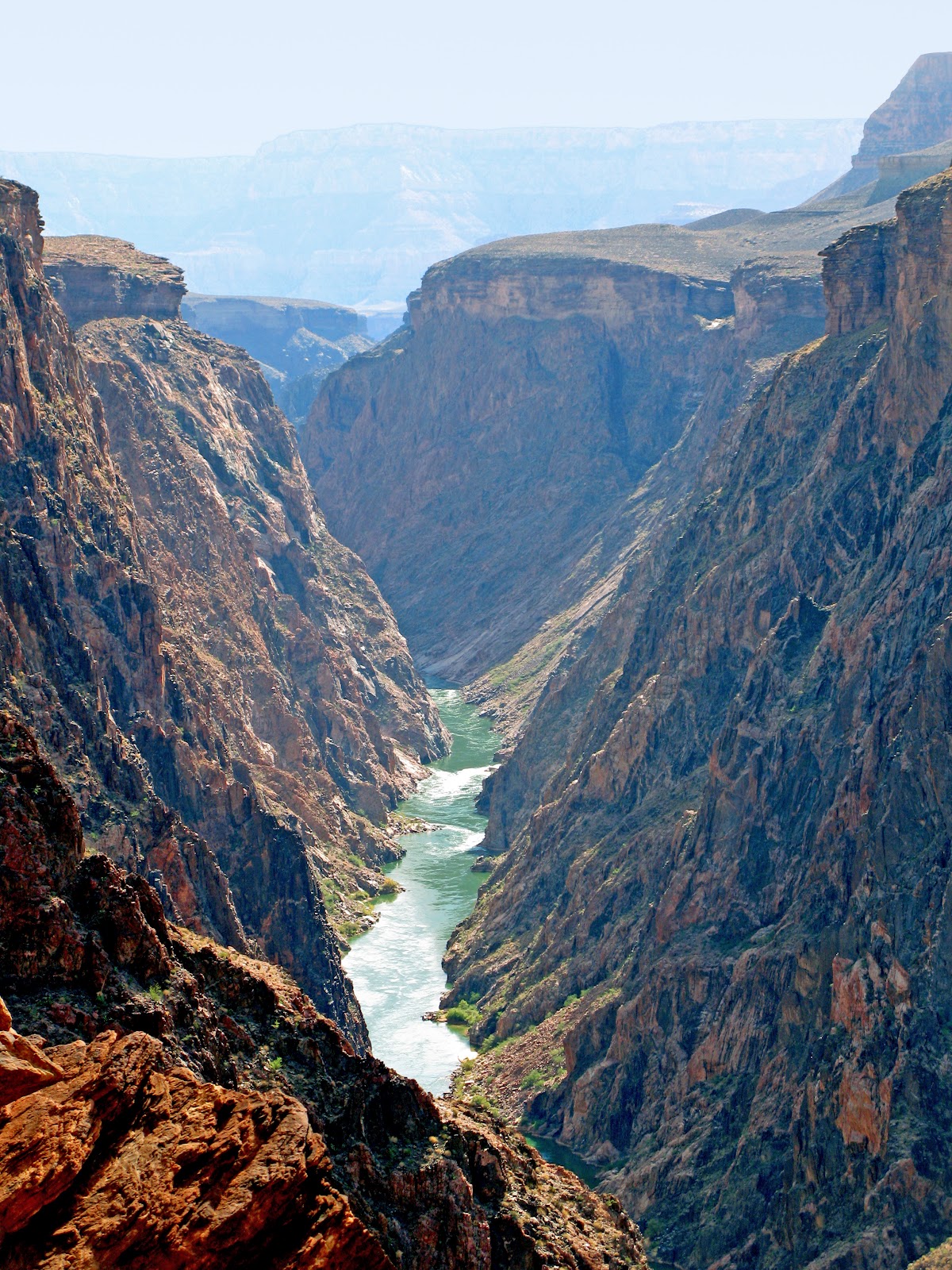
PHOTO BELOW: THE GREAT UNCONFORMITY
This spectacular view of the Grand Canyon is from Hopi Point on the canyon’s South Rim. That’s the Colorado River heading west carving a narrow gorge through the resistant, dark Vishnu Schist. Directly above, the Tapeats Sandstone forms a prominent cliff with the missing time of the Great Unconformity sandwiched in the contact between the two rock layers. The Tapeats and the draping-slope above it form the Tonto Platform, an expansive, broad bench and important landform within the Grand Canyon.
LOTS OF QUESTIONS
You can run your fingers from from the Vishnu Schist to the Tapeats Sandstone and literally touch the gap of lost time within the Great Unconformity. Where did over a billion years of time go? How can we attempt to comprehend its magnitude? Where did all the missing rock layers go? How were they removed? Were they ever there to begin with? What event or events caused this massive time-gap to form? Why did it happen at the end of the Precambrian? What happened during it? How do we know? Are the events global in their extent? Will it happen again? There are many questions. Let's attempt to unravel some of the mysteries of the Great Unconformity. But, before we review its contiguous stratigraphy, let's establish a few important definitions.
UNCONFORMITIES COME IN THREE FLAVORS
If successive rock layers that are deposited without interruption (think of an unbroken depositional sequence) are said to be conformable, then a break in stratigraphic continuity (think of deposition with interruptions) is called an unconformity. There are three types of unconformities, all of which possess a gap in the rock record and all of which are observable within the Grand Canyon.
A disconformity occurs when sedimentary rock layers are deposited, but erosion of the older, underlying layer has occurred. If after deposition, tectonic movement (such as during mountain formation) of the layers creates uplift, tilting and erosion, and then younger layers are deposited over the older, tilted rocks, an angular unconformity is formed. A gap in the record exists between the younger, horizontal package and the tilted, older package, which has a contact that is easier to recognize due to the non-parallel rock layers. Angular unconformities generally indicate a longer time hiatus than do disconformities, because the underlying rock is generally metamorphosed, uplifted and eroded before the overlying rock has been deposited. A nonconformity occurs when overlying sedimentary rocks are deposited directly over igneous or metamorphic rocks. As we shall see, the Great Unconformity is classified as a nonconformity.
The red lines in the diagrams below represent the contacts of the three types of unconformities: an angular unconformity, a nonconformity and a disconformity.
(Modified from Earth and Atmospheric Sciences, University of Alberta’s website)
A VERY ABBREVIATED GEOLOGICAL BIG PICTURE OF THE GRAND CANYON REGION
Under what geological circumstances did the rock layers above and below the Great Unconformity form? Let’s briefly investigate the geological events from the Early Proterozoic through the Cambrian in the region of the Grand Canyon. Of course there’s an even earlier story and a later story, geology never rests, but it's not germane to our immediate discussion.
I - LAYING DOWN THE BASEMENT OF THE GRAND CANYON
During the Early Proterozoic Era from about 1,600 to 1,700 million years ago, a cluster of oceanic island-arcs (first the Mojave, then the Yavapai, and finally the Mazatzal) collided with the growing supercontinent of Rodinia. Their accretion formed a dramatic, coastal mountain range as new crust was incrementally annealed to ancestral North America's growing southwest margin (western by a Cambrian global perspective) including the region of the future Colorado Plateau and Grand Canyon.
The following imaginative paleographic map by Ron Blakey, using tectonic scenarios that resemble the southwestern Pacific Ocean as a modern analogue, illustrates how Proterozoic crust in the Southwest may have been created. The red dot depicts the region of the contemporary Grand Canyon.
Early Proterozoic arcs drifting toward their inevitable subduction zones on Rodinia's southwest margin
(Modified from Ron Blakey, Colorado Plateau Geosystems, Inc)
This map of the contemporary Southwest depicts the Proterozoic crustal provinces that formed from the incremental amalgamations of the Mojave, Yavapai and Mazatzal arc-terranes to Rodinia's Wyoming Province, its ancestral cratonic core.
(From Dr. Mike Williams, from http://www.geo.umass.edu/)
Heat and pressure of the collisions metamorphosed the intervening mass of lava, ash, sandstone and mudstone into schist, gneiss and amphibolite at depths of 20-25 km. The resultant gnarled, foliated, Silly Putty-like, black rock unit is known as the Vishnu Schist (along with neighboring Brahma and Rama Schists), while the subterranean magmatic chambers and conduits (the plutons and dikes) that fed the fury formed the pinkish Zoroaster Granite (or Zoroaster Plutonic Complex).
The entire igneous and metamorphic package is formally known by geologists as the Granite Gorge (or Grand Canyon) Metamorphic Suite, but is commonly referred to as “Precambrian crystalline rocks”. These basement rocks form the foundation for much of southwestern North America including the Colorado Plateau and the Grand Canyon in particular. All the sedimentary sequences that follow are deposited on this groundwork.
PHOTO BELOW: THE GRANITE GORGE METAMORPHIC SUITE
Draped by greenish Bright Angel Shale, the horizontally-bedded Tapeats Sandstone forms a prominent cliff directly above the dark, foliated Vishnu Schist. The Great Unconformity resides in the contact between the two rock units. Notice the wavy, pinkish-dikes of Zoroaster Granite intruded into the dark Vishnu Schist. These rocks comprise the Granite Gorge Metamorphic Suite. The erosion-resistant, crystalline walls of the schist have confined the Colorado River to a narrow, swift channel called the Inner Gorge.

PHOTO BELOW: THE VISHNU SCHIST OF CLEAR CREEK
The meta-sedimentary Vishnu Schist of the side canyon of Clear Creek is so extensively metamorphosed that it is gneissic in appearance displaying marked foliation and boudinage. Sections are so heavily infiltrated by Zoroaster Granite that the schist has a pink marbled appearance.
Also notice the river-polish on the canyon's walls and the "clean look" of the canyon's bed. Heavy rains in the watershed upstream send a torrent of water through the side canyon. Over the millenia, the flood's burden of rocks have scoured the walls to a smooth sheen. Amazingly, the side canyon enters the mainstream Colorado River at grade having excavated down to river level. And as the flood subsides, it sends its rocky load into the main river channel leaving the side canyon's floor "clean" save a few cobbles here and there as the diminishing current looses its capacity to carry rock. The hydrological dynamics of the Grand Canyon's river system is truly fascinating!
PHOTO BELOW: THE ZOROASTER GRANITE
This extreme close up is of the truly spectacular Zoroaster Granite. It is classified as a coarse-grained pegmatite comprised of quartz, alkali-feldspar, mica and hornblende. It formed by partial melting of the lower crust during its deformation over a billion years ago. The Precambrian Vishnu Schist and Zoroaster Granite are considered to be the basement structures or foundation upon which the overlying strata of the Grand Canyon are built.
II – A VERY SUPER GROUP
By the Middle Proterozoic, the growing landmass of Rodinia had increased in size while the upper crust of the lofty mountains that formed from the collision of the island-arcs had eroded about 10 km to a broad, low-relief plain at sea level. Concomitantly, mid-crustal rocks were buoyantly exhumed (~1,300 to ~1,255 Ma) bringing the metamorphosed schist to the Earth’s surface. The metamorphosed, eroded and exposed cores of the mountains would eventually be overlain by the deposition of the Grand Canyon Supergroup during the Middle and Late Proterozoic. These events are integrally related to the development of the Great Unconformity.
THE ENORMITY OF THE SUPERGROUP
In 1869, John Wesley Powell recognized younger Precambrian rocks than the Vishnu and Zoroaster within the Grand Canyon as “Algonkian” in age and called them the Grand Canyon Series. Today, the Supergroup is comprised of an assemblage of nine different formations that have been combined into two large groups of formations, the Unkar and Chuar, and two interposed deposits, the Nankoweap and Sixtymile Formations.
The Supergroup is exposed in the eastern Grand Canyon and rests with angular unconformity on the Granite Gorge Metamorphic Suite, our basement Vishnu-Zoroaster complex. Taken as a whole, at over 12,000 feet in height, the Supergroup is over twice the height of the Grand Canyon from the rim to the river, and yet is buried beneath it! As we shall see, the Supergroup was later broken by faults, tilted into blocks and planed off by erosion.

The Grand Canyon Supergroup: the Unkar Group, Nankoweap Formation, Chuar Group and Sixtymile Formation. The Grand Canyon Metamorphic Suite underlies the Supergroup; the Tonto Group overlies it.
(Modified from unknown source from a GSA Bulletin)
WHERE IS THE SUPERGROUP FOUND IN THE GRAND CANYON?
The Supergroup, as a whole, is exposed as isolated, fault-bounded remnants along the main stem of the Colorado River within the Grand Canyon. Unlike the Unkar (yellow) which is exposed at several locations along the river, the Chuar Group (orange) is exposed only at one location. In the region of the Butte Fault, the western down-dropped section preserved the Unkar Group (placing the Dox Formation at river level) and the Chuar Group, deposited in the growing “sag” of the Chuar Syncline. Also note the Granite Gorge Metamorphic Suite (Vishnu and Zoroaster) exposed by the Colorado River (blue).
(From Bloch, Crossey, Karlstrom and Timmons, Modified from Timmons, 2004)
III – GRENVILLE OROGENESIS AND THE FINAL FORMATION OF RODINIA
THE UNKAR GROUP
During the Middle Proterozoic from about 1,255 to 1,100 million years ago, the largely-mudrock of the Unkar Group (red arrow) is thought to have been deposited intracratonically in an environment of extensional tectonism and sedimentation. Its deposition was in tectonic response to plate-margin deformation and crustal shortening during the Grenville Orogen (yellow). The Grenville was the final, protracted mountain-building and crust-forming event in the formation of Rodinia. Deposits within the Grenville Province are found worldwide (yellow).
(Modified from Karlstrom)
IV – THE RIFTING APART OF RODINIA
THE CHUAR GROUP
During the Late Proterozoic from about 1,000 to 740 million years ago, the Chuar Group and brecciated rubble of the overlying Sixtymile Formation were deposited in a synclinal, marine cratonic basin directly west of and during extension on the north-trending Butte fault system. The deposits are inferred to record rifting during the breakup of Rodinia at the dawn of the Phanerozoic Eon. In Blakey's map below, the Chuar Group was deposited in a shallow, marine basin, an arm of the sea that was periodically flooded by seawater.
A recreation of a Late Proterozoic extensional basin in association with Rodinian rifting
(Modified from Ron Blakey, Colorado Plateau Geosystems, Inc)
V - HORSTS AND GRABENS DICE UP THE SUPERGROUP
Rodinia began its inevitable breakup during the Late Proterozoic (~750 Ma) with the newly-forming continents of Western Australia and Eastern Antarctica pulling away from the west (see Karlstrom map above). Normal faulting left the Supergroup with a horst and graben (German words for “thicket” and “grave”) landscape of uplifted mountain ranges and down-dropped, tilted basins, offsetting adjacent blocks of crust almost two vertical miles. Portions of the Basin and Range Province of the Southwest today might be considered an analogous modern landform derived from extensional tectonics.
Ironically, the sedimentary layers of the Supergroup, originally flat-lying and possibly extending tens if not hundreds of miles, that became either uplifted, downdropped and tilted, would end up in a patchy, discontinuous distribution by the beveling of erosion, but only after the forces of the Colorado River exposed it all, over half a billion years later!
Rifting also affected the Grand Canyon region as movement along extensional faults tilted the rocks of the Grand Canyon Supergroup. The primary deformation that tilted the Supergroup strata is thought to have occurred before deposition of the upper Nankoweap Formation (~900 Ma) and the Chuar Group. Extensional deformation recorded in the Chuar Group is thought (Timmons, Karlstrom, GSA Bulletin, 2005) to be related to the incipient rifting of Laurentia, 200 million years after Unkar deposition and tilting.
VI – EROSION AND PRESERVATION OF THE SUPERGROUP
The towering, fault-uplifted horst ranges of the Supergroup were relentlessly attacked and lowered by erosion, completely removing the Supergroup to the extent that the Vishnu Schist and Zoroaster Granite became re-exposed. In places where extensional faulting had down-dropped the crust into rift-valleys, the Supergroup was buried and preserved (as if protected in its grave), forming the surface of the landscape. By the dawn of the Paleozoic, the landscape was nearly flat once again with the exception of a few hills and islands of Vishnu Schist and down-dropped remnants of the Supergroup that survived erosion. Erosion and preservation had taken its toll on the Supergroup.
PHOTO BELOW: THE CREMATION GRABEN JUST NORTH OF THE RIVER
About 750 million years ago during the breakup of Rodinia, a series of extensional faults lowered (white arrows show the displacement) a block of the Unkar Group known as the Cremation Graben into its “grave”. As erosion beveled the landscape and erased all traces of uplifted blocks of the Supergroup, this down-dropped block survived the ravages of erosion long enough to be blanketed by the Tapeats Sandstone during the Cambrian, but not entirely. An island of sparkling pink Shinumo Quartzite (a formation within the upper Unkar Group) projected out of the Cambrian sea out of depositional reach of the Tapeats. We’re truly viewing an ancient landscape!
In the photo below, can you identify the Cremation Graben and its Shinumo island? Can you locate the Cremation Fault between the graben and the Vishnu Schist, the schism in the crust along which the block of Unkar Group deposits faulted downward? Are you able to differentiate the stratigraphic layers of the Unkar Group visible here: the basal Bass Limestone, the reddish slope of Hakatai Shale and the uppermost cliff of resistant Shinumo Quartzite? Lastly, can you find the Great Unconformity (between the Tapeats Sandstone and the Vishnu Schist) and the “lesser” unconformity (between the Tapeats and the Shinumo Quartzite)?
Here’s the same photo with guide-lines added for identification. Notice the Great Unconformity (upper right) between the overlying Tapeats Sandstone and the Granite Gorge Metamorphic Suite and a “lesser” unconformity (upper center) between the Tapeats and the underlying Shinumo Quartzite. The Cremation Fault runs obliquely to the line of sight in the photo.

(Thanks for the help interpreting this one, Wayne)
PHOTO BELOW: THE CREMATION GRABEN JUST SOUTH OF THE RIVER
The Cremation Graben is bounded by the Cremation Fault on its northeast and by the Tipoff Fault on the southwest. The graben has actually been sliced in two by the Colorado River. The southern block in the photo below is seen from high up on the Clear Creek Trail looking south from across the river. That’s the South Kaibab Trail (left) switchbacking its way down the Cremation Fault, through the orangish Hakatai Shale (upper left) and skirting to the left of a cliff of Bass Limestone. Here, the rocks of the Supergroup were eroded to a great extent before the Tapeats was laid down. The fault has offset the Bass which is lying above the Vishnu Schist. Further to the right (center top) a second normal fault also offsets this portion of the lower block of Unkar deposits. Notice the incredible extent that the pinkish Zoroaster Granite has injected throughout the black Vishnu Schist giving it a marbled appearance.
The tectonic situation here is analogous to the normal faults seen on the east coast of North America in response to Pangaean rifting during the Late Triassic and Early Jurassic that ultimately generated the Atlantic Ocean, only here the faults bear witness to the breakup of Rodinia. The Rodinian breakup on its western shore created the continents of Australia and Antarctica, while the Pangaean breakup on its eastern shore created Europe, Africa and South America.
PHOTO BELOW: THE “CARBON CAMP” BUTTE
We're looking south from Carbon Camp (64.7 river mile) at the entrance to Lava Canyon on the north shore of the Colorado River within the Grand Canyon. The tall, angular butte across the river is formed by upper Unkar Group deposits capped by the Tapeats Sandstone (above the white line). The lavas of the Cardenas (directly below the white line), the uppermost Unkar Group deposit, was emplaced in response to regional crustal extension as a tectonic by-product of the continent to continent Grenville collision on Rodinia’s eastern and southern coasts. The white line also represents the contact of a very large unconformity of perhaps 200 million years. Below the Cardenas lies the Dox Sandstone, near the base of the butte to the right with the rest of the Unkar graben buried in its grave below level.
This down-dropped block of the Unkar Group, having accordingly survived erosion, was uplifted along the Butte Fault which raised land to the west over 1,400 feet. When the lavas erupted, they were near the Dox shoreline, and the Tapeats sediments that followed (much later) were deposited on top of the lavas. About 2.5 miles upstream the Tapeats was at river level. Its lofty perch on the Cardenas seen here will be brought back to river level in about 50 miles downstream.
VII - RISING SEAS
The mountains that formed during the suturing of the terranes to Rodinia's southeast continental margin have long eroded away, as well as the uplifted ranges of the Supergroup. The geological stage was set for fluctuating high seas to gradually inundate coastal and cratonic low-lying regions not just regionally but globally. Over 5,000 miles of Laurentia's miogeocline that formed after Rodinia rifted apart in the Late Proterozoic flooded during the Cambrian.
That worldwide, high-water event is known as the Sauk transgression, one of six during the Phanerozoic. Beach sands of the Tapeats were about to be deposited on the buried remnants of the ancient mountains by the encroaching Cambrian sea in the region of the future Grand Canyon.
Cambrian high seas flood Laurentia's subsiding miogeocline
(Modified from Ron Blakey, Colorado Plateau Geosystems, Inc)
VII – THE TONTO GROUP
Scotese’s Middle Cambrian paleomap shows Rodinia’s rifted continental siblings having tectonically dispersed across the globe. The two largest are Gondwana, largely South Polar in location, and Laurentia, located equatorially. Laurentia is rotated 90° clockwise compared to its contemporary orientation. The Grand Canyon region (red dot) was inundated by Panthalassic high seas which flooded low-lying regions of all the continents. The Tonto Group was deposited in the region of the Grand Canyon during this interval. It was also the time of a seemingly-abrupt “explosion” of marine life in the global seas. Only 75 million years earlier, a relatively short period of time geologically, life in the seas was largely unicellular.
(Modified from Scotese.com, 2002)
As the Panthalassic Sea rose, it gradually encroached upon the land. Coarse sandy
beaches and offshore sands of the Tapeats Sandstone were the first of the Tonto Group’s tripartite members to be deposited in shallow waters. In deeper waters, finer clastics of marine muds of the Bright Angel Shale followed, and in still deeper waters, calcitic deposits of the Muav Limestone. All the deposits of the Tonto Group are in gradational and confo
(Modified from Nations and Stump, 1981)
VIII – LOTS OF MISSING TIME
The Tapeats Sandstone came to be the Grand Canyon’s oldest and deepest Paleozoic layer resting upon the Grand Canyon’s Precambrian basement rocks. Where the Supergoup had been completely removed by erosion, the Great Unconformity formed above the Vishnu Schist. Where down-dropped sections of the Supergroup was preserved, a large unconformity developed, the size of which is contingent on what section of the Supergroup had been preserved. For example, where down-dropped sections of the Unkar Group was preserved, its base rests on the rocks of the Grand Canyon Metamorphic Suite creating a major unconformity of about 475 million years while its top has a hiatus approaching 600 million years. Where the top of the Chuar Group is juxtaposed to the Tapeats, a mere 200 million year time gap exists.
Many geologists have employed the use of comparative terms such as "lesser", "great" and "greatest" to describe the relative size of the gaps in time in association with the Precambrian basement rocks. But in the lexicon of geology there exists only one Great Unconformity, a time gap in which the others don't even come close.
PHOTO BELOW: THE GREAT UNCONFORMITY AND ZOROASTER INCLUSIONS
We are viewing the Great Unconformity at arm’s length within Blacktail Canyon. Blacktail is a popular locale for literally touching the Great Unconformity in the serene setting of a beautiful side canyon. The regional westard dip in the strata has caused the Tapeats Sandstone to descend back down to river level making the details of the Great Unconformity well exposed to view along the river-polished walls of the canyon. In addition, Blacktail Canyon has a great little echo, and if you're really quiet, you can still hear the waves of the advancing Cambrian sea crashing onto the shore as it churns up loose chunks of granite and schist.
According to the geological Principle of Inclusions, clasts are older than the rock in which they are contained. Notice the “loose” fragments of Zoroaster pegmatite from the underlying Grand Canyon Metamorphic Suite incorporated within the contact below the basal-most Tapeats Sandstone. Inclusions can often be utilized to recognize a nonconformity such as this.

PHOTO BELOW: THE GREAT UNCONFORMITY AND VISHNU INCLUSIONS
This view of the contact is nearby the above one in Blacktail Canyon only with Vishnu clasts embedded completely within the matrix of the Tapeats. The transgressing Cambrian sea laid down the Tapeats over this loose Vishnu rubble and incorporated it into beach sand that eventually lithified. The Great Unconformity is a few feet below.
PHOTO BELOW: THE GREAT UNCONFORMITY WITHIN THE GRANITE GORGE
This strikingly beautiful beach within the Upper Granite Gorge along the river is littered with erratics of black Vishnu Schist and pink Zoroaster Granite. Notice the pegmatite dikes emplaced into the Vishnu matrix in the massive block along the river's edge. The Great Unconformity is directly below the Tapeats on both sides of the river.
PHOTO BELOW: PLATEAU POINT AND THE CHEOPS PYRAMID
That's me standing on the edge of time on Plateau Point at sunset, located at the end of a promontory on the broad terrace of the Tonto Platform. Five more feet and it's a 1,320 foot free-fall into the Colorado River at the bottom of the gorge. The Point is an easy stroll from Indian Garden, a camping oasis of cottonwood trees 3,120 feet below the canyon's South Rim. The gently undulating bedrock beneath my feet is the Tapeats Sandstone, and under that is the Great Unconformity juxtaposed above the Vishnu Schist.
Across the gorge is some incredibly beautiful and equally complex geology. My gaze is at the Cheops Pyramid. It's another erosion-surviving, down-dropped block of the Unkar Group. One would assume that's the Tapeats Sandstone at the same level across the gorge (barely visible center right), but it's actually the Bass Limestone, the lowermost Unkar unit. Above it is the shaddowed-slope of orange-red Unkar's Hakatai Shale with a prominent cliff of resistant Shinumo Quartzite higher up. This particular unit of Shinumo was an offshore island in the Cambrian sea. The sloping Bright Angel Shale and the cliffed Muav Limestone crown the pyramid, only without the basal Tapeats since it undoubtedly projected too high above the sea to receive Tapeats deposition but high enough to receive the rest of the Tonto Group. The key to interpreting the stratigraphy is to not so much look at one layer but the relationships between the layers. Of course, a bedrock map will serve as a confirmation.
So where is the Great Unconformity? It's a trick question. In the photo, it's only on our side of the river between the Tapeats and the Vishnu Schist where an uplifted block of the Unkar Group was removed by erosion. On the far side of the river we have a "lesser" unconformity (of perhaps 600 million years) between the Shinumo Quartzite and the Bright Angel Shale.
Photo (and stratigraphic assistance) courtesy of Wayne Ranney
LAST PHOTO: THE ANGULAR UNCONFORMITY AT APOLLO'S TEMPLE
Perhaps the most photographed angular unconformity appearing in geology textbooks is the one seen from Desert Tower situated on the eastern South Rim of the Grand Canyon. That's the North Rim in the distance (about 9 miles away), and below it lies the Paleozoic sedimentary column from the Kaibab Limestone down to the Tapeats Sandstone. In front is the sprawling, camouflaged butte of Apollo's Temple (center), held up by a large block of the Unkar Group that runs from the base of the Tapeats (white line) to the river in the foreground (not seen).
Notice the obvious tilt of the entire Unkar Group relative to the horizontality of the Tapeats creating an angular unconformity with the base of the Tapeats. The banded shales and sandstones of the Nankoweap Formation overly the basalts of the Cardenas Lava, and the orange-red Dox Sandstone slopes to the river. Where each of these formations contacts the white line of the Tapeats is a "great" angular unconformity with varying time gaps ranging from about 600-700 million years.
My white line depicting the "great" unconformity at the base of the Tapeats continues off the photo to the right. Beneath the Tapeats here lies the beginning of a lower portion of the Chuar Group deposited in a syncline just to the west of the Butte Fault.
What tectonic event is responsible for the tilting of the Supergroup before the Tapeats was deposited? Of course, it's the rifting of Rodinia.
(Thank you marlimiller.com)
MORE QUESTIONS THAN ANSWERS
The first step in defining the complexities associated with the Great Unconformity begins with an understanding of its stratigraphic relationships. Fortunately, the Supergroup was preserved in down-dropped blocks affording geologists an opportunity to begin to reconstruct what happened geologically, climatologically and biologically during the enormous interval of missing time. Unfortunately, as anticipated, the answers have generated even more questions.
Why is the end of the Precambrian often marked by an unconformity? Why was the interval so long? Did global "Snowball Earth" glaciation influence Chuar deposition? What lifeforms, if any, existed during the period? Did the geological events of the period favor or disfavor their evolution and diversification? What caused the Sauk transgression following the rifting of Rodinia? Sounds to me like the introduction to another post.