Virtually every geology-based road trip I've been on has had its share of unforgettable side trips, off beat detours and unplanned turn offs. The best part, second to the geology, was the adventure of the unexpected and the inexplicable waiting at every turn.
That’s when you see the unusual signage, the eccentric pieces of art, the unique architecture, the kitschy sculptures, the cheesy tourist stops, the poignant juxtapositions, and all the wacky, tacky, bizarre and oddball attractions that are so characteristic of Roadside America. It’s also when you find remnants of vanishing America - the diners, drive-ins, juke-joints and storefronts that have been thoughtfully preserved or recklessly abandoned to the ravages of time.
Here's what I stumbled on this November while traveling with my friend and geologist Wayne Ranney on the roads and backroads between Phoenix, Arizona and the Mexican border. This is my third post in this series in what has become a tradition following our geological excursions. The other two may be found in the "Index to Topics" in the column to the right under "Roadside America."
 |
| Literally across the street, beer and chicken headline a newer version of the menu today. Nothing gets my digestive juices flowing more than an enormous chicken alongside my table. |
 |
| This "masthead" decorates one corner of the building. |
 |
| This demising wall across the street was intensely muralled. Notice the graffiti proclaiming "Old Bisbee." |
 |
| And this creative gallery sign was next door. The "Five C's" of Arizona's economy are: Cattle, Copper, Citrus, Cotton and Climate. Bisbee deserves a sixth "C" for Creative. |
 |
| Here's a 60's mega food-sculpture in newer Bisbee, down in the flats below the Lavender Pit mine. Bisbee is the nation's southernmost mile-high city. |
 |
| Believe me now? |
 |
| When was the last time you saw a gas pump that looked like this? That's glass not plastic! |
 |
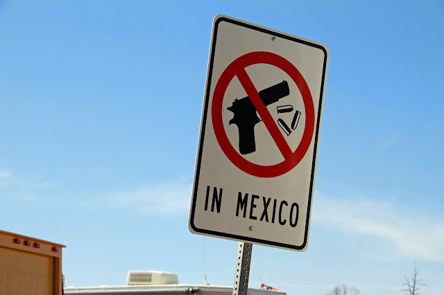
| In far southern Arizona, this sign was a first for me. Any guesses precisely where we are? |
 |
| Here's a hint. |
 |
| We're in Naco, Arizona, at the Border Fence or Wall between Mexico and the United States. 96.6% of apprehensions along the 1,951-mile border between the two countries occurs along the country's southwest boundary and traverses a variety of terrains including urban areas and deserts. The barrier strategically exists where illegal crossings and drug trafficking have existed in the past. In addition to the physical barrier, a "virtual fence" of motion sensors and video cameras watches everything and everyone that moves. Note three of them on tall poles down the road. We counted over two dozen white Border Patrol vehicles on maneuvers in one hour. Critics in Arizona and Texas assert that the fence adversely isolates endangered species in critical migration corridors and jeopardizes fragile ecosystems much the way roads and canals have compartmentalized the Florida Everglades (recent post here). In 2010, a Rasmussens Reports survey indicated that 68% of Americans are in favor of the U.S.-Mexico Border Fence. |
 |
| Right next door was an antique railroad car gradually decomposing into the landscape. You never know what you're gonna find. |
Thanks again, Wayne.


Jack - This may be your best posting yet in the Roadside America series. I remember seeing all of this, but viewing them again through your "lens" makes them come alive!. Thanks for the outstanding post. Wayne
ReplyDelete