"With looking comes understanding but not before total confusion!"
Geologist, author, teacher, guide, good friend Wayne Ranney, 2020
Geologist, author, teacher, guide, good friend Wayne Ranney, 2020
Back in grade school in the '50s, well before the advent of plate tectonic theory, I distinctly recall my geography teacher commenting on the curious geometric fit of the continents that border the Atlantic Ocean. Was it possible they were once unified in a single globe-spanning landmass? At the time, it seemed so unlikely but so intriguing. The same could have been said for the slender Baja California Peninsula, whose contour mimics the west coast of mainland Mexico.
They're both consequences of large-scale plate kinematics. What's more, the Baja is located on the Pacific plate along with a generous slice of western California, but that wasn't always the case. How did this geo-magic happen, and what's going on at Los Cabos at the tip of the peninsula? The answer lies on the seafloor of the Gulf of California and has everything to do with the San Andreas Fault.
They're both consequences of large-scale plate kinematics. What's more, the Baja is located on the Pacific plate along with a generous slice of western California, but that wasn't always the case. How did this geo-magic happen, and what's going on at Los Cabos at the tip of the peninsula? The answer lies on the seafloor of the Gulf of California and has everything to do with the San Andreas Fault.
 |
| North View of the Southeast Coast of Baja California Sur and Gulf of California In the distance, the town of La Paz lies on the Baja's largest bay within the La Paz block to the north of the Los Cabos block. The region is crisscrossed by active normal faults and forms part of the Gulf Extensional Province. The gulf islands are stranded blocks of thinned continental crust that formed when the gulf transtensionally opened. |
ABOUT THIS POST
It's about the geological evolution of Los Cabos at the southern tip of the Baja California Peninsula but takes into account the large-scale tectonic processes that gave birth to western North America. Indeed, "Nothing in geology makes sense except in the light of tectonics" (Lynn Fichtor, Ph.D., personal communication, 2012).
Italicized terms in this post are defined, important names are highlighted in boldface where first mentioned, and global coordinates of various locations are provided that can be pasted into an on-line mapping program such as Google Earth so you can "Go there."
 |
| "Bienvenido a Cabo" The NS-trending San Jose del Cabo extensional fault separates the Sierra de la Laguna range from the San José del Cabo basin and its multi-bedded alluvial plain on which the airport was built. |
While most geology field trips afford the participants some downtime from the rigors of exploration, my recent sojourn to Cabo was the complete opposite. Between inescapable demands of the beach, pool, shopping and dining out (I was with my wife and another couple), I managed to squeeze in a little productive geo-time (They were most accommodating).
Fortunately, numerous roadcuts, rocky outcrops, nearby summits, aerial views during take-off and landing and even morning strolls on the beach provided a good sense of what's going on. The following is what I observed, while on the go (and travelling light with my cellphone for a camera).
 |
| Sunset over Bahio de San Lucas In the distance, Land's End is the southernmost extent of the Baja Peninsula at the town of Cabo San Lucas. It's also where marine waters of the Pacific and Gulf of California intermix. |
WHERE IS LOS CABOS?
'The Capes' (or simply 'Cabo') defines the region at the southernmost tip of the Baja California (or simply the 'Baja'), which refers to 'lower' California. In the vernacular, Cabo also refers to Cabo San Lucas, its famous resort city. The Baja is a peninsula that dangles some 1,247 km to the south from the American state, making it the second longest one in the world (The Arabian Peninsula is longest and largest). About the size of West Virginia, it varies from 320 to 40 km wide with a pristine coastline ~3,280 km long.
The Pacific Ocean lies to the west, and to the east the Gulf of California separates it from mainland Mexico and the Sierra Madre Occidental range. The two bodies of water meet at Land's End or Finisterra, just south of Cabo San Lucas. The Gulf is also known as the Sea of Cortez that hearkens back to the region's Spanish explorer and conqueror, although the official name was changed to Golfo de California in the early 20th century.
 |
| Map of the Baja California Peninsula It covers an area of 71,777 sq km and is politically divided into Baja California Norte and Baja California Sur in the south, although in 1979 it officially became one. It's a land of steep NNW-SSE trending granitic mountains, coastal valleys, Sonoran deserts (65%) and hundreds of pristine islands and inlets. |
The Gulf is a marginal sea like the Sea of Japan. By definition, they're subdivisions of oceans between islands, archipelagos and the like that opened in extensional tectonic regimes. The Sea, however, formed in the extensional back-arc region of a subduction zone (where tectonic plates converge). On the other hand, the Gulf formed when subduction converted to an oblique transform margin that opened transtensionally.
In part, the explanation is the essence of this post.
A SPINE OF GRANITE
The Peninsula Range forms a nearly continuous N-NW-trending spine from just south of Los Angeles to the tip of the Baja Peninsula at Los Cabos. It's a string (~1,200 km) of hundreds of exhumed (unearthed by erosion and lateral collapse) batholiths (deeply buried, solidified magma chambers >100 sq km) that emplaced during an oceanic plate collision (at least one) with an overriding continental plate.
The long axis of the range is geophysically partitioned into two lateral zones that parallel the range's axis: an older, more mafic western section and a younger, more felsic eastern one. It also has northern and southern segments that differ genetically across an obscure crustal boundary. The challenge has been determining the genetic relationship of the lithospheric elements and whether single or multiple accreting (or re-accreting) east-migrating arcs were involved.
 |
| Northernmost Peninsular Range South of Los Angeles It's part of the North American Coast Ranges from Alaska to Mexico and on a grander scale, part of the Cordillera, the vast and tectonically complex collection of ranges in western North and South America built by at least six major orogenic (mountain building) events along actively colliding plate margins. |
POORLY UNDERSTOOD GEOLOGY
In addition, outcrops of the range not only appear as the Puerto Vallarta Batholith across the mouth of the Gulf of California from Los Cabos on mainland Mexico but to the north in eastern California as part of the basement of the Sierra Nevada range. What's more, the outlier granites reside on the North American plate, whereas the Peninsulars once did and now resides on the Pacific plate to the west. How did this stupendous feat of geo-magic occur? What's going on out West?
But first, let's explore colorful Los Cabos.
We stayed on Corredor de Oro or the Corridor of Gold, which refers to the value of real estate versus mineral wealth. It's a busy, southernmost section of paved Carretera Federal or the Transpeninsular Highway that zigs and zags 1,711 km from Tijuana down to Los Cabos. It opened the Baja to vehicular travel, but you'll need 4WD for remote roads along with a healthy dose of Mexican backcountry fortitude (here).
The 33 km-long corridor connects the cities of San José del Cabo and Cabo San Lucas on the west. Although 20 minutes apart, they couldn't be more different. Quiet San José is a small but growing, working-class colonial city, while antithetical Cabo San Lucas (or just 'Cabo') is the famous party destination known for its nightlife that everyone (over 3 million per year) associates with the region. World-class resorts and luxury hotels in between provide a quiet respite for the celebs that flock there and the common folk (like me).
 |
| Misión de San José del Cabo Añuití on Plaza Mijares In the heart of the colonial town's historic district, it was instituted for conversion of native Pericú into the Catholic faith. It was the southernmost Jesuit mission on the Baja Peninsula, established in 1730 at the Pericú settlement of Añuití. Its proper name of Misión Estero de las Palmas de San José del Cabo Añuití refers to the waters of the life-saving river-estuary near which it was built. Go there: 23°3'43.78"N, 109°41'43.09"W |
Cabo San Lucas' central plaza is actually a marina, where tourism, commercialism and nightlife are in full-swing. Well-to-do expatriates, retirees, the rich and famous, and sundry vacationers from up-north contribute to the party atmosphere and its wealth, noted by what's floating in the marina and tucked up in the hills around town.
On quiet morning strolls around the marina you'll be confronted (politely accosted) by hordes of restaurateurs that try to coax you in for a meal, while hucksters appear every 20 feet and compliment you on your shirt (or my mustache for me) to get you to take a harbor cruise across the Bay of Cabo.
 |
| The Marina of Los Cabos This is where it's happening, whatever that may be. Go there: 22°52'57.53"N, 109°54'34.96"W |
Additional comic relief is provided courtesy of the Brown Pelicans that hang out on the boats and eat fish, while sea lions suddenly appear from below the surface and steal their catch. It's a colorful and crazy place, but good geology awaits elsewhere (after breakfast).
 |
| Pelican in the Marina of Cabo San Lucas |
IS THE WATER CERULEAN BLUE OR AQUAMARINE?
It's no surprise that the big draw is the desert climate (hot days and cool nights, but always sunny and dry), the local cuisine (Try the fish tacos!) and marine locale (with an endless horizon of beach, world-class fishing, whale watching and scuba diving). The 20th century French explorer Jacques-Yves Cousteau called the Gulf the "Aquarium of the World" due to the abundance of diverse marine life that graces its waters.
There's also over a dozen championship golf courses, horseback riding galore and lots of good vibes bolstered by a potent infusion of Mexican tequila. I've added geology to the region's list of accolades, but it's enhanced by a working knowledge of western North American tectonic history and Mesozoic through Cenozoic plate kinematics.
 |
| Playa Costa Azul and Cuatro Amigos It's one big beach along the corridor. This one is a mecca for those seeking big surf served up with adult beverages and good Mexican grub. This place was literally on the beach, where Dee, me (upper left), Marti and Hal partook in adult libations and sumptuous fish tacos. We got there early, evidenced by the lack of crowds and with a singer-guitarist all to ourselves. Do go there: 23° 1'40.09"N, 109°42'54.66"W |
Here are a few geological site suggestions in and around Los Cabos worthy of visitation.
#1 - RESERVA DE LA BIOSFERA LA LAGUNA
It's one of the most beautiful, least explored and under appreciated areas of Cabo and only 25 km north of San José del Cabo. Established in 1994 as a 11,600 hectare UNESCO biosphere protected reserve, it's one of several on the peninsula and the gulf's 244 islands. It was named for a dry lakebed ('laguna' in Spanish) now meadow in the Laguna range between peaks Picacho de la Laguna and Cerro la Aguja that exceed 2,000 m.
The reserve has a rich and highly diverse ecosystem for such a southern semiarid region with oak and pine woodlands at cooler, higher elevations and tropicals at base level that thrive among massive blocks of eroded, Cretaceous granite. With great biological and geological rewards, the lush and rugged biosphere is perfect for geologists, casual day-trippers and hardcore backpackers (here and here).
 |
| Tropical Flora and Granitic Rocks of the Biosphere Reserve Note that there are several hot springs in the reserve and one near Cabo San Lucas. Mexico is the fourth largest producer of geothermal energy in the world. Go there: 23°33'59.90"N, 110° 0'0.00"W |
#2 - ESTERO SAN JOSÉ DEL CABO
Immediately east of town is a biological oasis that's easily overlooked but easy to reach and explore on hiking trails by bike or on foot. Bound by a coastal sandbar, it's where the freshwater aquifer of Rio San José that's buried beneath a massive arroyo (steep-sided, seasonally dry wash) travels some 48 km from its origin in the Lagunas and mixes with salty, estuarial tides from the Gulf. The aquifer is recharged by the large watershed of the Lagunas that funnel torrential rains during wet-season tropical cyclones to the river.
 |
| West View of Estero San José I snapped this lucky shot at take-off. The lush green preserve and estuary lie between the old town of San José del Cabo (bottom right) on the west and the boat-filled of Marina Puerto Los Cabos on the east. Upstream from the preserve sprawls the wide and normally bone-dry arroyo of Rio San José. The river parallels the San José del Cabo fault and eponymous basin tilt to the sea. Unfortunately, as the town grows in size and the water table lowers, the estuary's fragile ecosystem is threatened. |
The 1,166 hectare reserve, which is actually a remnant of the river that flowed naturally before the century, stands in mark contrast to the sun-parched, dusty brown, seasonally dry wash upriver. Its steep banks preserve bedded horizons of alluvial sediments that, beginning in the Miocene, funneled down primarily from the Lagunas on the west. The arroyo records a late Pleistocene-early Holocene history of a wetter paleo-climate punctuated with episodes of millennial-scale flooding from southeast hurricanes.
 |
| Northwest View of the Estuary The town of San José del Cabo abuts it immediately to the west against a backdrop of Sierra de la Laguna. |
The reserve's 125 bio-rich protected acres are home to saline tolerant, tall Tlaco palms, draping willows, grass-like sedges and tall cattails with vast submarine 'meadows' of slender Eelgrass. There are over 250 species of shore and waterbirds (and their avid birdwatchers) that winter there or are year-round residents. They include herons, terns, vireos, yellowthroats, egrets, Turkey vultures, caracara and osprey.
There are no alligators but abundant reptiles and amphibians such as frogs, iguanas, lizards, geckos and snakes. The lagoon and aquifer, which in reality largely protected only by name, is gradually succumbing to unregulated anthropogenic depletion by land development, nearby hotels, golf courses and general domestic purposes.
 |
| The Tropical Sanctuary and Freshwater Coastal Lagoon of Estero San José The river is the largest source of freshwater in the arid Baja. Much of it travels underground some 48 km to the lagoon at the mouth of the river. Ringed by sandbars, growth is nourished by detritus of dead plants from the Lagunas watershed that settles to the riverbed by suspended salt from the sea. The reserve is at risk from over-exploitation by the rising population and golf course use that causes seawater intrusion into the aquifer. Go there: 23° 3'9.02"N, 109°41'5.89"W |
#3 - EL ARCO
Sculpted by wind and wave near Cabo San Lucas spans the dramatic headland of Land's End and its heavily joint-fractured granitic sea arch. Ready to collapse into the sea at the next storm, it's symbolically synonymous with the town as evidenced by its image on T-shirts, shot glasses, mugs, posters, brochures, place mats, towels, postcards and even bottles of tequila. We've seen it before - the convergence of geology and marketing!
You can reach the arch from the west at low tide from the hotels or hike to it across Mount Solmar. You can also float there across oft-choppy Cabo Bay with any of the unrelenting tour vendors in nearby Cabo San Lucas. The hike is short but slightly challenging, and for a small fee (Remember: This is Mexico!), Enrique will keep his dogs at bay, open the gate to the trailhead and even be your guide.
 |
| El Arco on Land's End from Bahia San Lucas facing South The sea stacks (isolated rocky sentinels), called The Friars (Los Frailes in Spanish) by Steinbeck, may have supported arches that succumbed to the combined fores of wind and wave. They are purportedly frequented by hordes of basking sea lions. |
A moderately steep descent delivers you to Lover's Beach (Playa del Amor) on the Gulf north of the arch that's connected to Divorce Beach (Playa del Divorcio) on the Pacific to the south (Choose your beach based on your marital preference).
#4 - MOUNT SOLMAR
Mount Solmar is the center-summit of Land's End. Its Late Cretaceous exhumed granite is coevally, lithologically and mineralogically similar with that of the Baja's backbone, although debate is ongoing regarding its enigmatic orogenic history, which may not be representative of the entire peninsula. The Peninsular batholith appears to be part of a belt that includes the Puerto Vallarta batholith on the Mexican mainland from which it was contiguous before opening of the Gulf of California (explanation forthcoming).
 |
| West View of Cabo San Lucas from Mount Solmar That's the Bay of Cabo of the Gulf on one side of the headland and the Pacific on the other. A number of dark, Fe and Mg-rich xenoliths became entombed in a batholithic magma chamber after being dislodged from country-host rock. Densely populated Cabo San Lucas (right) on the Gulf's Bay of Cabo and the hotels of Divorce Beach (extreme left) on the Pacific are separated by the headland. |
From the summit, a great view unfolds of the Pacific to the west, Cabo Bay and its resort city to the north and, to the east, the southernmost Gulf of California that gently caresses La Playa, the world-famous beach of Los Cabos. In the distance, the Sierra la Trinidad range resides in the basin of San José del Cabo. Mainland Mexico is over 350-400 km due east, from which the Baja Peninsula originated!
 |
| Los Cabos and Southern Gulf of California from Mount Solmar |
#5 - FOOTHILLS OF SIERRA DE LA LAGUNA
The southernmost range of the Peninsular Batholith ends in eroded foothills that reach the sea in a tapering array of outstretched granitic arms. They're easy to access and climb, but you'll have to pick and choose a trailhead from unmarked access points off the corridor road. We chose one behind a golf course-condo complex and tipped the guard to let us cross the private property in case he called security (Again, this is Mexico).
The summits provide sweeping views of the coast, and you'll get a good perspective of the arroyos that exit uprange canyons, cut through draping alluvial fans and poke through the coast's long dune field before reaching the marine waters of the gulf.
 |
| View of a Laguna Summit from the Coast |
In the Miocene, tectonics that uplifted the region that facilitated formation of the coastal alluvial plain, while to the east (left) across normal (extensional) faults, a sedimentary basin dropped down and received deposition from both continental and marine sources. Large-scale plate movements that initiated the process began in the Mesozoic.
 |
| Facing the Gulf to the South across the Corridor of Gold |
DECEIVINGLY SERENE
After leaving seismic Los Angeles and flying to quiescent Cabo, one of my travel companions commented that it looked like there were no earthquakes to experience. He couldn't have been more wrong. In reality, the regional serenity is deceiving. Just off the coast, the seafloor of the Gulf is scored with tectonic scars that record active spreading since the Miocene.
Here's a seismic snapshot of larger quakes that occurred in the southern Gulf of California during the last five years. Their curvilinear nature on the seafloor follows an oblique rift that has been extending the Gulf of California and gave rise to the geographic independence of the Baja from mainland Mexico from which it separated. Notice the near-perfect gap in the coast from which the Baja originated.
 |
| Southern Gulf Five-Year Seismic History In the last year, five sizable and countless smaller earthquakes have occurred. The largest are at a depth of 10 km and vary in magnitude from 4.1 to 6.1 off the gulf coast of Los Cabos. One occurred near Cabo's La Playa beach two months before the writing of this post. From Earthquaketrack.com |
A SUITE OF GRANITIC DIVERSITY
Half-way to the summit, an easy climb in the manageable morning heat, an unexpectedly abrupt bedrock transition occurs from a cream-colored granite at lower levels to a reddish-orange one. The switch reflects a mineralogical change in composition from rich to poor potassium feldspar. Their curious juxtaposition sets the mind to seek a petrological explanation for the association.
What's more, the lower creamy granite is indurated, while the upper warm-colored one is friable or 'rotten' in consistency and easily crumbles apart in hand. It accounts for the loose, coarse-grained chunks of rock and gravelly sand that litter the slopes and trails of the foothills.
 |
| Two Diverse but Associated "Granites" Dominated by feldspar with other minerals thrown in and less than 5% mafics and less than 20% quartz, monzonites are typically found around the edges of continental felsic plutons. It explains their proximity in the Laguna foothills and corridor roadcuts throughout the region. |
RHYMES WITH 'GOOSE'
The chunks are grus, an angular breakdown product of granite. Working in concert, chemical and mechanical weathering alters the structural and chemical fabric of crystalline rock, which weakens it. Grusification occurs in every climate regime but accelerates in the warm and humid conditions of the region especially during the wetter Quaternary.
• Chemical weathering occurs via plagioclase decomposition, atmospheric carbonation, iron oxidation, hydration, hydrolysis and fossil fuel acidification.
• Mechanical weathering occurs via microcrack disintegration, hydrothermal alteration, biotite iron oxidation, water absorption and expansion. It includes cataclastic breakdown by crushing and grinding from tectonic crustal movements.
In time, weathering results in the formation of a mixture of clays (largely from feldspars and micas), silt and and erosion-resistant, silica quartz sand that forms the foot-scratchy beaches of Cabo via water and gravity-transport.

A number of dramatic roadcuts on the coastal highway slice through long granitic arms of the Laguna foothills that reach the sea. They expose the same magmatic-mix of granite that we saw on our ascent of the Laguna foothills. In most cases, there's no safe shoulder to pull over for exploration, so I shot from our moving vehicle.
What petrological and tectonic explanation might account for their combined presence and curious juxtaposition? Did one intrude the other or did they form bimodally in close association within the Peninsular range's deeply buried batholith?
Let's hypothesize.
 |
| Complexly Interdigitated Granites in a Corridor Highway Roadcut |
BIMODALISM
The light-colored rock is monzonite. It's a relatively uncommon igneous rock similar in appearance to syenite, its mineralogical 'cousin' (See ternary diagram below). It's found in the Peninsulars along with related tonalites and granodiorites. Geologists collectively refer to them as 'granitic' or 'granitoid' rocks versus the orangey-red rock, which is a "true" or felsic granite that's rich in silica and feldspar and imparts a warm color to the rock. They're all encircled on the QAPF diagram below.
Granitic rocks are the most abundant rock type in the continental crust. Referred to as plutonic or intrusive igneous rocks, they form when molten magma cools, crystallizes and solidifies below the Earth's surface versus volcanic or extrusive rocks that form when lava lithifies on the surface. In the Peninsular range, the granites solidified within a series of batholiths that formed parallel to the Farallon subduction zone and fed an arc of volcanoes at the surface.
 |
| Types of Magma Intrusions A batholith is a very large mass of intrusive igneous rock that forms and cools deep in the Earth's crust. Hot magma is less dense that the surrounding rock in which it forms or intrudes. As a result, it tends to rise toward the surface and result in volcanic eruptions. Plutons, a general term for igneous intrusive bodies, include batholiths, the largest, irregular-shaped body that feed various magma-containing and magma-delivering intrusive structures. Modified from Motilla of Wikimedia Creative Commons |
GRANITIC CLASSIFICATION (VERY ABBREVIATED)
The classification of igneous rocks is one of the most complex and confusing aspects of geology. They're classified by a number of systems such as mineralogical and chemical composition, color, texture and based on various processes of emplacement. One such system is a double ternary QAPF diagram that depicts the mineralogical ratios of Quartz-Alkali Feldspar-Plagioclase-Feldspathoid and is used mostly to classify plutonic rocks.
Here's the upper half of a diamond-shaped QAPF diagram that focuses on the Peninsular's suite of granitic rocks and shows their petrological relationships (the study of rocks and the conditions under which they form).
 |
| The Peninsular Range's Suite of Plutonic Igneous rocks The QAPF ternary diagram provides a classification scheme, one of many, for plutonic igneous rocks based on a four-part mineralogical composition: quartz (Q), alkali feldspar (A), plagioclase feldspar and feldspathoids (F, not shown). Many of the Peninsular granites are intermediate between reddish-pinkish felsic (silica and potassium feldspar-rich) and dark-colored mafic rocks (silica- silica-poor and Mg and Fe-rich). |
Simply stated, with less than 5% quartz and nearly equal amounts of potassium and plagioclase feldspar (35% to 65%), monzonite and its granitic affiliates (QAPF diagram) are classified as intermediate rocks on the spectrum between felsic and mafic (dark-colored, silica-poor and Mg/Fe-rich) igneous rocks. An example of the region's latter are gabbros.
The bimodal association conveys information about the subduction regime that occurred in a convergent continental margin setting. The granitic suite formed during the evolution and crystallization of a magma-melt. Monzonites, for example, are thought to form around the edges of continental felsic plutons (the true granite), where mingling and mixing of magma end-members occurs. That would explain their bimodality.
Back to our hike in the foothills.
"PLANTS AND BIRDS AND ROCKS AND THINGS" ♪♪♪
From the summits, you can easily spot the granitic headland of Land's End and nearby Cabo San Lucas. It's the southernmost point of the Baja Peninsula and location of the arch where the Pacific meets the Gulf. Even with all the construction, dense vegetation and golf course greenery you can identify a number of elevated alluvial terraces indicative of periods of uplift and/or sea level change that affected sedimentation.
You can also spot Turkey vultures (two on upper right) gracefully riding thermals in lazy circles. Long-lived with a starkly bare red-head, six-foot wingspan, keen sense of smell (Rotting meat is more odoriferous than fresh) and excellent eyesight, the numbers imply plentiful carrion but hundreds of the swooping scavengers can actually feast on a single carcass of desert rat or jack rabbit.
 |
| West View of the Los Cabos Coast |
The Baja also offers a diversity of desert plants well-suited to the Baja's semi-arid climate. There are widely-scattered understories of the evergreen shrub Larrea tridentata or Creosote (a medicinal herb), yucca (unknown species) and Lomboy (nature's milky-sapped Chapstick) that cling to the grus-blanketed soil. Here and there, the landscape is peppered with tall organ pipe, prickly pear, agave and barrel cactus.
Adaptive strategies working in concert to conserve moisture and avoid desiccation include waxy and hairy cuticles, shallow roots, reduced evaporative surface areas, light-reflecting colors, water storage, stomatic leaf pores that open at night in association with a variant of photosynthesis, nocturnal bat pollination, reduced metabolism during drought, rapid growth following rainfall, and sharp spines and bitter taste to deter ingestion.
 |
| Organ Pipe Cactus Typically found in rocky Sonoran deserts on hot sunny slopes and pollinated by bats at night, Stenocereus is indigenous to Mexico and parts of the Southwest. Its water-storing trunks make it the second largest cactus next to the Saguaro. Known locally as 'pitaya dulce', beneath its rugged external flesh lies a sweet watermelon-like fruit. |
There's also a vast array of colorful Sonoran wildflowers that thrive in the sun-drenched hills (that defied my ID capabilities). Examples (below) include Fouquieria splendens, a red flowering, cane-like, branched ocotillo, which is not a true cactus, and the delicate, ground-hugging, four-petaled, yellow Sun Cup Camissonia angelorum that loves clayey, granite-weathered soils.
The tall yellow-flowered infloresence (arranged on a stem) is Aloe vera (I think). I'm not sure of the variety, since there are many of these succulents (water storage beneath thick fleshy leaves). There's also a number of spectacular eye-catching Solanum hindsianums. Known as Hinds' or Sonoran Nightshade, it's related to the Southwest's Sacred Datura in family Solonaceae and therefore likely hallucino-poisonous.

Many of the region's indigenous plants and herbs were used medicinally and spiritually by the Baja's natives. (P.S. Flora Farms' spa, market, educational classes and restaurant in the foothills of the Sierra de la Laguna range near San José del Cabo offers informative botanical walks in the 25 acre desert around the farm).
GEO-STROLLS ON THE BEACH
Our early morning constitutionals were not only highly therapeutic but geologically enlightening. Facilitated by jointing, large photographic boulders of felsic granite that litter the beach are highly weathered, jointed and wave-rounded. The coarse, scratchy sand underfoot is a breakdown product of the grus delivered by water-transport and gravity from the Laguna foothills.
 |
| Los Cabos Coast Facing East Jointed knobs of Laguna range granite litter the beach at the sea's edge that are a haven for marine life in the tidal zone. In the distance beyond San José del Cabo, a southern arm of the Sierra de Trinidad range reaches the sea. The mainland Mexican coast lies over 525 km due east across the Sea of Cortez. |
A number of monzonitic erratics were embedded in the sand. One possessed a section of a faulted gabbroic dike, the mafic igneous rock found in the range. One can't be certain when the mafic dike injected into the gran0-felsic host rock or when it was subsequently offset (displaced in the parent rock), given the complex formative and protracted stress and strain history of the Los Cabos region.
Genetic speculations include late Mesozoic emplacement and petrological evolution of the batholith, the tremendous release of pressure from erosion of overburden and subsequent exhumation (exposure and uplift) that followed in the Cenozoic. There's also subsequent uplift and tectonic transportation during opening of the Gulf beginning in the Miocene that was accompanied by mafic-dike seafloor magmatism. Explanations forthcoming.
 |
| Faulted Gabbroic Dike in Monzonitic Beach Erratic Notice the coarse, scratchy quartz sand derived from the grusification of granitics. |
HOW THE PENINSULA (AND THE AMERICAN STATE) MISTAKENLY GOT ITS NAME
Before delving into the region's tectonic history, let's glance at Cabo's once-perceived, erroneous geography. Beginning some 3,000 and possibly as far back as 11,000 years ago (and possibly much earlier), the region was occupied by the now-extinct Pericú. They're a subgroup of the Las Palmas group of southernmost Baja California Sur that lived simply in huts, caves and on open ground and survived as hunter-fisher-gatherers.
It's thought that they rafted to the region in the early Holocene via transoceanic currents from the Pacific Southwest. In fact, DNA testing of scant remains and craniometric morphology have confirmed that they share a lineage with the Australian aborigine.
 |
| Two Pericú Women Drawn by English privateer George Shelvocke, who visited the Cabos region during the early 18th century. From Wikimedia Commons Public Domain |
IN COME THE SPANISH
Spurned by victory over the Moors after 700 years of conflict, Spain emerged in the 15th century as the most powerful nation in Europe and ruler of the high seas. Turning their attention to the New World and fueled by stories and discoveries of mineral riches, a succession of Spanish explorer-conquistadors crossed the Atlantic, the Caribbean, Mexico and Central America. Most famous was Hernándo Cortés in the 1530s (Cortez in English).
 |
| Cortex in the New World Conquering Mexico, Hernando Cortez is welcomed into the Aztec temple in 1519 by Emperor Montezuma II, who thought he was of god at the beginning of the Spanish conquest of the Americas. The calendar stone and cult images are based on sketches that artist Constantino Brumidi made in Mexico. The work of three artists in 1877, the panoramic frieze adorns the Rotunda of the U.S. Capitol. Wikimedia Commons Public Domain |
Motivated by finds in the Aztec capital of Tenochtitlan, which Cortez ceremoniously conquered, and tales of great wealth in the legendary Seven Cities of Cibola of the New Mexico Territory, he headed for the Baja in search of "pearls and gold" and hopes of a marine connection between the Atlantic and Pacific. His contingency reached it in 1535, which at the time was thought to be the island of Califa or Califia, and sent Francisco de Ulloa ahead for exploration of its perimeter in 1539.
 |
| Cortez Reaches the Natives of Baja California Sur The founding of the La Paz, the contemporary capitol city of Baja California Sur by Hernando Cortez on May 3, 1535. From bajainsider.com. |
A GULF WITH MANY NAMES
De Ulloa was the first to sail to the head of the Gulf but was deterred by strong currents of “water white, like river water.” It was undoubtedly the mouth of the then free-flowing Colorado River and correctly suggested to him (but unconvincingly to others) that Califa was not an island and the ocean was a strait.
He called the sea Mar Bermejo or the Vermillion Sea, possibly motivated by the river's iron oxide-colored delta waters or perhaps a reddish phytoplankton bloom that often occurs there. Motivated politically shortly afterward, Spaniards adopted the name Mar de Cortés or Sea of Cortés. Later in the 1500s, Golfo de California or Gulf of California was adopted. Today, the last two variably appear on American and Mexican maps.
 |
| The Assumed Island of California off the Coast of Nova Granada The map is a concoction of early exploration and creative guesswork. Note that cartographers have designated Califia as California. Notice that there are no official lines of longitude on the map, but that's the subject of a future post. From Wikipedia Commons Public Domain by Dutch cartographer Johannes Vingboons in 1650. |
A LONG-HELD EUROPEAN MISCONCEPTION
The island's appellation (and namesake of the American state) came from Spanish author Garci Rodríguez de Montalvo's romance novel entitled "Las Sergas de Esplandián." In it, he described a mythical island close to the Garden of Eden ruled by the black, courageous warrior Queen Califia, an Islamic-inspired name, and her formidable force of man-eating, lion-eagle hybrid griffins.
"Know ye that at the right hand of the Indies there is an island called California,
very close to that part of the Terrestrial Paradise (legendary Mexico of ease and riches),
which was inhabited by black women without a single man among them,
and they lived in the manner of Amazons. They were robust of body
with strong passionate hearts and great virtue. The island itself
is one of the wildest in the world on account of the bold and craggy rocks."
Spanish author Garci Rodríguez de Montalvo, 1500
 |
| Mural of Queen Calafia in the Mark Hopkins Hotel of San Francisco Wikimedia Commons Public Domain |
Her name for the landmass stuck, when Spanish and Dutch cartographers used it for the Baja in the 1500s and Alta ("Upper") California for the American state in the 1700s. To call the Baja an island was erroneous but a prescient assumption, since it is on track to become one, given its present tectonic trajectory.
THE ISLAND BECOMES A PENINSULA AND THE OCEAN BECOMES A GULF
For over 150 years, explorers still assumed the body of water was the Pacific and the landmass an island. That changed in the early 1700s, following the arrival of Spanish missionaries that spread Christianity to the indigenous peoples.
Unfortunately, earliest maps of Spanish explorers in the 1530s and '40s still depicted an island. The composite 1767 French map (below) shows a progression that explorers and mapmakers held in regards to the peninsula's insular nature. What is clear is that it was names California before the state and later acquired its Baja or "Lower" designation.
 |
| French Carte de California (Baja) Map Montage Over Time Carte de California (aka Baja California) is shown as a peninsula in every view exception II, in which it is depicted as the Isle of California. I, Map of America by Mathieu; II, Sanfon, 1656; III, Sepi, 1700; IV, Jaruites, 1705; V, Society of Jesuits, 1767. From raremaps.com |
A report submitted by Jesuit explorer Padre Eusebio Kino, who conducted an overland expedition above the Sea of Cortez, finally cast serious doubt on the island concept. The ongoing geographic conundrum officially ended in 1775, when King Ferdinand VI of Spain issued a final decree, but it was another century for European cartographers to comply. If you're interested, more interesting historical details are here.
 |
| Baja California's connection to the mainland finally appeared on maps such as this by . Notice the Rio Colorado emptying into the Mer de la California and the Mer du Sud (South Sea) to the west of a Part of California. |
CABO IN MODERN TIMES
The Pericú's demise was multi-causal. Severe drought around year 1,000 promoted inter-tribal warfare over competition for dwindling natural resources (a lesson for us all). The end came in the mid-1700s after increasing European contact, when the natives were subjugated and killed by Jesuit missionaries and conquering Spanish and when they succumbed to Old World diseases lacking natural resistance (here and here).
In the 1930s, tuna canning put Cabo on the map, but a hurricane in 1941 devastated the factory, followed by WWII patrolling Japanese subs that deterred tourism and caused the region's abandonment. In the 1950s, Hollywood's rich and famous began to fly there and stay at its burgeoning new hotels. Construction of the Transpeninsular Highway in 1974 opened the door, and it's now one of the fastest growing destinations in Mexico.
 |
| An Empty-Looking Cabo San Lucas in the '50s To the north, the rocky headland of Land's End and Mount Solmar is in the foreground, the southernmost point on the Baja Peninsula. Photo from 1956 by James Stewart and UC. |
A NEAR-PERFECT FIT
Perceptive mapmakers, geographers and geologists have long-noticed the puzzle-like fit of the coastline of the continents across the Atlantic realm, as if at one time they had been unified. The concept actually goes back to 1589, when Belgian cartographer Abraham Ortelius hypothesized that they were "torn away" by "earthquakes and floods."
Over three hundred years later in 1912, German scientist-meteorologist Alfred Wegener offered an explanation for Continental Drift related to planetary motion. Labelled "Utter damned rot!" by some members of the scientific community, it failed to explain how the fragmented continents of Pangaea could somehow "plow through the sea" across the Atlantic. It would have failed to answer how the faithful curvature of the Baja mimics the slender gap along mainland Mexico's western margin.
 |
| Descriptio Maris Pacifici The first dedicated map of the Pacific and Americas, "Description of the Pacific Ocean", was drawn by the Dutch geographer-cartographer Abraham Ortelius in 1589. Notice that the Baja is no longer represented as an island and that the Gulf is called Mar Vermejo. Modified from Wikimedia Public Domain. |
By the mid-20th century, a host of independently working earth scientists such as Harry Hess (seafloor spreading), J. Tuzo-Wilson (hotspot) and William Morgan (mantle plumes) culminated with the formulation of Plate Tectonic Theory (the Ancient Greek word 'tekton' means 'builder'). Although many aspects of it are challenged, it's the unifying concept in geology that describes migrating and subducting lithospheric plates of crust driven by mantle cooling and convection.
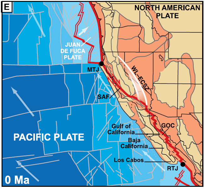
It accounts for Pangaea's late Paleozoic assembly, its Mesozoic fragmentation and Cenozoic redistribution and the Baja's geo-transfer from the North American to the Pacific plate. Although the latter event initiated in the Miocene only 6 to 10 million years ago, the tectonic groundwork began much earlier in the Mesozoic. Let's go back in time.
SETTING THE STAGE
For over 150 million years, the western margin of North America, while part of supercontinent Pangaea and later as the continent of North America, has been the site of a diverse array of tectonic plates and smaller terranes (fault-bound, transported blocks of crust) that converged upon and accreted to (collided and amalgamated) the nascent growing continent.
Each collision added crust to its expanding western margin as older rocks were deformed and metamorphosed and new arced lines of volcanoes spewed their contents across the landscape. One mountain range after another was uplifted as North America's elongate mountainous Cordillera began to form.
 |
| North American Plate Paleography in the Late Jurassic (150 Ma) Pangaea has initiated break-up, as the embryonic Atlantic and Gulf have begun to open and Africa and South America have begun to depart. The northwest-migrating Farallon oceanic plate has become established with its leading edge colliding with the western margin of the North American plate. A myriad of smaller terranes have preceded the Farallon that contributed to its crustal growth and participated in the uplift of the Cordillera. Modified from Ron Blakey's Colorado Plateau Geosystems, Inc. |
THE FARALLON SUBDUCTION ZONE
The longest-lived, largest and most important to collide was the Farallon oceanic plate. It formed in the proto-Pacific in the Late Jurassic (~160-155 Ma), when its leading edge began to converge northeast and descend into the mantle beneath the west-migrating, thicker and more buoyant western margin of the continental North American plate. The event established the Farallon subduction zone at the oceanic-continental plate interface and radically altered the structure and topography of the western continent.
 |
| Farallon Subduction Zone The convergent plate boundary includes a sinking Farallon oceanic slab and an overriding North American continental plate. The zone includes a deep marine trench, a line of boundary-parallel volcanoes with a deeply buried, magma-feeding string of batholiths and a host of structural and topographic changes inland such as a thrust belt in the hinterland and fore-arc basin in the foreland. Modified from Chapter |
BACKBONE OF THE BAJA
In Jura-Cretaceous time, the 800 km-long Peninsular Range was the result of the Farallon collision and possibly a number of smaller oceanic terranes that converged on North America in the Cenozoic. The range's long volcanic arc spanned the coastal margin of southern California and Mexico across the region that would later give birth to the Baja.
In the Paleogene, the range's batholithic core began to cool as surface erosion and melt-induced buoyancy gradually exhumed it to the level of the sea and blanketed it with continental sediments. In the Neogene, tectonic processes divided the range between Baja California and various outliers on mainland Mexico across two tectonic plates. The event left Los Cabos at the tip of the Baja Peninsula with two southernmost Peninsular remnants - Sierra de la Laguna on the west and Sierra la Trinidad on the east.
 |
| Exhumed and Eroded Batholithic Remnants of the Peninsular Range on Western Mainland Mexico |
Our story wouldn't be complete without a discussion of the ramifications of the death of the Farallon plate and what ensued geologically in the Gulf of California.
DEPARTURE OF THE FARALLON AND ARRIVAL OF THE EAST PACIFIC RISE
Ongoing convergence and descent of the east-migrating Farallon plate resulted in its consumption within the trench of its subduction zone. In its wake, the northwest-migrating Pacific plate followed. Think two oceanic plates moving apart while travelling continentward as one (See opposing arrows below).
While migrating in unison, the two oceanic plates were separated by an elongate volcanic ridge and valley called the East Pacific Rise (EPR). It's a divergent plate boundary, where extension and thinning lithosphere between the two separating oceanic plates permits upwelling magmatism to create new crust on the seafloor of both plates.
 |
| Simplified Schematic of Three Plates Converging in Unison Eastward subduction of the Farallon plate beneath the overriding North American plate allows the East pacific Ridge between the Farallon and Pacific plates to migrate toward the Farallon subduction zone. Entry of the EPR into the subduction zone will convert tectonic convergence to transform motion and form the San Andreas Fault System as an elongate slice of the NA plate is transferred to the Pacific plate. |
THE EPR VERSUS THE MAR
For clarification, the East Pacific Rise and the Mid-Atlantic Ridge (MAR) between the North American and Eurasian plates are magma-generating seafloor features fractured by faults at intervals. Like the stitching on a baseball, they're major segments of a ~65,000 km-long, circum-global system of spreading centers between diverging oceanic plates.
Although referred to as "mid-ocean" by convention, they differ in that the EPR is non-equidistant from the Pacific realm continents, since the ocean is closing unevenly at different rates, as evidenced by the number of active subduction zones distributed on the Ring of Fire that surrounds the ocean. The EPR is also wider and steeper, since the Pacific spreading rate is faster (120 km/myr or 6-16 cm/yr) than the Atlantic (2.5 cm/yr).
 |
| East Pacific Rise and Mid-Atlantic Ridge Only Farallon remnants are subducting along the western margin of North America. The Nazca remnant (and a portion of the Antarctic plate) are subducting beneath western South America, while the East Pacific Rise spreading center is well out to sea as it converges. |
Let's focus on what happened when the Farallon plate met its fate.
LATEST OLIGOCENE(?) - EARLIEST MIOCENE (~20 Ma)
An early Miocene time traveler visiting southwest California and northwest Mexico would have witnessed the demise of the Farallon plate as its trailing edge entered the trench of the Farallon subduction zone with the Pacific plate right behind separated by the East Pacific Rise.
Poorly understood, the Farallon plate began to fragment into smaller microplates. Some remained active, while others were incorporated into the Pacific plate. Modern active remnants include Juan de Fuca in the Northwest, Rivera and Cocos of western Mexico and Central America and Nazca along western South America. There are two small ones off the coast of the Baja - Guadalupe and Magdalena - that played into its evolution.
• As the EPR entered the subduction zone, it encountered the overriding North American plate and gave birth to the San Andreas Fault System (SAFS) at ~28 Ma.
• As the Pacific and North American plates progressively converged, the contact zone between the two plates progressively began to lengthen.
• Two triple plate junctions formed - the Mendocino TPJ in the north and Rivera TPJ in the south - that mark the progress of the advancing EPR and developing SAFS.
• Since ~30 Ma, plate convergence at the expense of the Farallon began the evolution of an Andean-type continental margin (oceanic lithosphere descends beneath continental lithosphere with volcanic mountain construction).
• Notice that the Baja remains attached to mainland Mexico, and the Gulf is unopened.
 |
| Earliest Miocene Paleography of Southwestern North America and Northwestern Mexico The life of the Farallon ended, as remnant microplates continue to subduct beneath North America. The SAF has begun to develop north and south and inland with extension continentward (orange blob) toward the developing B&R. Gulf of California is unopened, and the Baja is still attached to mainland Mexico with a continuous Peninsular backbone. Modified from Faulds and Henry, 2008. |
BIRTH OF THE SAN ANDREAS FAULT SYSTEM
The arrival of the EPR at the Farallon trench reconfigured the Farallon-North American plate boundary from a subduction-convergent to a transform margin (side-to-side, parallel-to-the-plate-boundary motion) between the Pacific and North American plates.
The motion assumed a dextral direction, as the further plate moved to the right (versus sinistral to the left). It was inherited by the SAFS from the northwest direction of the Pacific plate relative to the west-migrating North American plate. Rather than being a single fault, as is often assumed, the SAFS is a complex right-lateral transform system of dextral faults and subsidiary folds, normal faults and even sinistral faults.
Its Miocene evolution has had enormous consequences for the landscape (and future) of the western continent.
| Farallon-NA Plate Convergent Motion Converts to Pacific-NA Plate Transform Motion Modified from ThingLink.com. |
EARLY MIOCENE (~15 Ma)
The Pacific plate converged obliquely upon the North American plate as the SAFS began to develop. As it advanced, rifting with seafloor spreading occurred in the Gulf of California as the Baja separated from mainland Mexico. The events are subject to a number of interpretations and models. The following panels are from Faulds and Henry (See Bibliography).
• With the death of the Farallon and subsequent convergence of the Pacific plate, the nascent SAF began to advance both north and south AND inland in seismically-punctuated, fault-generating jumps.
• Coupling of the Pacific and North American plates resulted in the tectonic capture ('conversion' or 'transfer') of an increasingly larger slice of western North America.
• As the land grab progressed and Pacific-North American plate dextral motion was preserved, the Pacific plate continued on its northwest, out-to-sea trajectory along the transform margin (white arrows). It has given rise to the fear that California will someday "fall into the sea" during "The Big One" - a 7.8 magnitude or higher meg-earthquake along the southern SAFS.
 |
| Early Miocene Paleography of Southwestern North America and Northwestern Mexico As the Pacific plate continues to converge on the North American plate (while tracking northwest), the SAF, WL-ECSZ and B&R continue to develop as the MTJ and RTJ continue to separate. The unopened Gulf and Baja remain attached to the western Mexican mainland. Modified from Faulds and Henry, 2008. |
WHAT'S HAPPENING INLAND?
By 17 Ma in the mid-Miocene, western North America inland of the SAFS in the mountainous region built during the collision of the Farallon plate initiated a radical change in structure and topography. The Basin and Range province roughly encompasses California east of the Sierra Nevada range through Nevada to central Utah and, bypassing the Colorado Plateau, southern Idaho into central Mexico (orange blob above).
Formed by broad crustal extension (as much as 900 km) across normal-extensional faults, it's a vast and arid landscape characterized by NS-trending horsts (chains of rugged fault-bound, tilt-uplifted, eroding mountains) that alternate with grabens (downdropped, sediment-filled, flat valleys). Death Valley is a famous example. In 1880, geologist Clarence Dutton likened the region to an "army of caterpillars marching toward Mexico."
 |
| East-West Cross Sectional Schematic through a Basin and Range Extensional Landscape Each unit is separated by high-angle, normal (extensional) faults along which the ranges were uplifted and the basins subsided. Low-angle, normal detachment faults formed due to gravitational instability of uplifted blocks along which is considerable horizontal displacement. We will see a similar structure at Los Cabos on a smaller more limited scale. From TASA Graphic Arts, Inc. |
The subject of intensive debate, the physiographic province's provenance is multi-phasic and the combined result of both inter- and intra-plate mechanisms. It includes:
• back-arc extension in the hinterland (inland of the volcanic arc) of the Farallon subduction zone;
• gravitational collapse (under its own weight) of overthickened crust of the orogenic (mountain-built) highlands constructed during the collision of the Farallon plate;
• SAFS encroachment of the transform that relaxed and reversed Farallon compression;
• passive ascent of magma in response to crustal stretching and thinning that may have contributed to extension.
WHY IS THE B&R IMPORTANT TO THIS POST?
Because it may have "channelized" extension in the region of the future Gulf of California. In Mexico, the Basin and Range has two sections separated by the Sierra Madre Occidental range. The main section extended in the late Oligocene-early Miocene and an elongate arm to the west of the range (orange on Middle Miocene map below) followed in the middle to late Miocene. So?
Both sections began to extend before that of the Gulf Extensional Province to the west. The similarity in orientation, timing and proximity of the western branch and unextended future Gulf has given rise to the thought that extension was localized within the Gulf, having been sandwiched between the Occidentals and the Peninsulars. That might classify the region as one big extensional province and the Gulf Province as part of the B&R.
 |
| Basin and Range Topography of Southwest Nevada Death Valley is a familiar example but there are over 400 others. Early pioneering geologist Clarence Dutton described the landscape as "an army of caterpillars marching toward Mexico." Window smudges are courtesy of American Airlines. |
Let's return to the developing San Andreas system in the Miocene.
MIDDLE MIOCENE (~12 Ma)
• During periodic inland steps of the SAFS, sizable portions of North America began to transfer to the Pacific plate, while advancing southward toward the yet-to-form Baja (dotted white line) and unopened Gulf (black extensional arrow)
• East of Sierra Nevada, dextral motion of the SAF has increasingly been assumed by the east-developing system of the Walker Lane and Eastern California Seismic Zone (WL-ECSZ), although the style of deformation differs.
• As the SAFS advanced, the Rivera TPJ initiated an abrupt 1,000 km-long, southward jump (red dotted line).
• In the Southwest, B&R extension surrounded the Colorado Plateau on three sides, while down in Mexico, its western branch may have localized extension in the Gulf.
 |
| Middle Miocene Paleography of Southwestern North America and Northwestern Mexico The San Andreas fault system (SAF) is lengthening north-south and stepping inland as the Mendocino (MTJ) and Rivera (RTJ) triple plate junctions grow further apart. The Baja peninsula (dotted white arrows) is attached to mainland Mexico with unopened gulf and Los Cabos at the tip (dotted red). Anticipated extension in future gulf (black double arrow). B&R (orange blob) bufurcates at Sierra Occidentals. Black ellipse refers to Panels A-C. Modified from Faulds and Henry, 2008. |
The Gulf of California is one of the best examples of an oblique continental rift. With unclear timing, kinematics and genetic relationships, a number of interpretations and models exist. In essence (Spoiler alert!), the bi-phasic process involves dextral shear developing between the Pacific and North American plates (following oceanic plate subduction along faults to the west of the Baja) before onset of dextral-transtentional shearing in the Gulf that tore the Baja from the mainland.
Here are the details. Let's zoom in at the developing region (black ellipse above). A lot is going on. Here's a nice three-panel model by Fletcher et al (See Bibliography) beginning in the Middle Miocene:
PANEL A - MIDDLE MIOCENE SUBDUCTION (~12.3 Ma)
• The subduction of Farallon-remnant microplates Guadalupe and Magdalena (green) stalled when the Pacific-Farallon spreading ridge approached the subduction zone at the recently identified Santa Margarita and Tosco-Abreojos fault zones.
• The EPR continues to progressively enter the trench of the Farallon subduction zone.
• Pacific and North American plates continue to migrate dextrally (black arrows) with the Gulf unopened and the Baja still attached to the mainland.
• The Peninsular range is continuous from southern California to Los Cabos (dotted blue circle) and mainland Mexico at the state of Jalisco (dotted red circle).
 |
| Three-Panel Kinematic Evolution of the Gulf of California and Baja Peninsula A, Farallon microplates (green) subduct along Baja. B, Subduction ceased, as en echelon transtensional shearing (red ellipse) develops in the unopened proto-Gulf as the Baja microplate migrates northwest. C, Gulf is opening as Baja rifts from mainland Mexico on the Pacific plate. Dextral motion (black arrows) indicated of Pacific and North American plates. A and B, Los Cabos (blue circle) and conjugate Jalisco blocks (red circle) support a continuous Peninsular spine of granite that separated in C. Modified from Fletcher et al, 2007. |
• Microplates Guadalupe and Magdalena have coupled to the overriding North American plate as the Baja California microplate is captured by the Pacific plate.
• Oblique subduction at ~12 Ma converted to oblique dextral shear in the unopened Gulf.
• Transtensional shearing (side-to-side, strike-slip faulting with extensional components) has developed as the subduction zone converted to Pacific plate shear (below).
• The WL-ECSZ and Gulf Extensional Province demonstrate similar inland progressions of the transform boundary at different stages of evolution.
 |
| Schematic of an Idealized Oblique, Divergent Fault Zone In such regimes of an oblique, bending nature that deviate from simple shear, transpressional and transtensional features develop both on land and seafloor. In the Gulf, strain localization has created sediment and lava-filled, sigmoidal-shaped pull-apart basins, block rotations and large-offset strike-slip faults. Death Valley and Salton Trough are terrestrial pull-apart examples. Modified from Legg, 2007. |
PANEL C - EARLY MIOCENE TO PRESENT RIFTING & SEAFLOOR SPREADING ( 7.8 Ma - 0)
• Oblique divergent rifting aligned with the SAFS initiated ~6 Ma in the southernmost gulf as it unzipped to the NNW between the Pacific and North American plates (black arrows).
• Seafloor spreading permitted extrusion of largely basaltic lavas that began to form oceanic crust at 3 to 3.5 Ma (pink).
• As extension rifted the Baja microplate from the mainland, the Peninsular range separated from the mainland Mexico as marine waters invaded the Gulf from the south.
• The ~50 km-long Alarcón Rise (below) becomes the southernmost oblique spreading center in the Gulf. In contrast to the lengthy, uninterrupted SAFS, the Gulf's transforms are short segments offset by fracture zones, which are narrow zones of broken seafloor arranged en echelon (stair-like), roughly orthogonal (90°) to the oblique dextral transform system.
• The Tamayo fracture zone (FZ) is the southernmost one and links with the East Pacific Rise at the Rivera junction of the triple Pacific-North American-Rivera plates.
• The oblique NA-Pacific plate boundary connects to the SAFS in the north through the Salton Trough pull-apart basin and EPR in the south beyond the Rivera TPJ.
• The Guadalupe-Magdalena remnants (green above), having thinned and possibly windowed, facilitated magmatism and deformation along the west and east margins of the proto-gulf. It likely accounts for Miocene-age acidic volcanics that blanketed portions of the northern Sierra Trinidad range of Los Cabos.
• Gulf extension has a profound affect on the geology of the Los Cabos block (LC).
 |
| Tectonics of Gulf of California and Southern Baja California Microplate The Gulf Extensional Province is a step-like, axial array of en echelon transforms that link to a system of narrow spreading centers. The Alarcón Rise is the southernmost spreading center in the Gulf. Beyond it lies the Tamayo fracture zone and the Rivera TPJ at the junction of the southern segment of the East Pacific Rise and the Farallon-derived Rivera microplate. A network of NNW-striking normal faults are distributed on the gulf seafloor and on land across conjugate margins of the Baja and mainland. Plio-Quaternary-age oceanic crust (pink) emanates from the seafloor spreading centers. Modified from Fletcher et al, 2007. |
Gulf extension is responsible for a ~N-S trending basin and range-style of topography at the tip of Baja California in the Los Cabos block and adjoining San José del Cabo basin. The block (a distinct tectono-stratigraphic terrane) is represented by the exhumed, intrusive Mesozoic granitoids of Sierra la Laguna and is separated from the rest of the peninsula by the active, normal La Paz-Carrizal fault complex.
The largest and dominant fault of Los Cabos is the ~150 km-long, high angle, active normal San José del Cabo fault that controls the basin to the east. Smaller, fairly shallow and later to form Los Barriles (LBB) and La Paz basins abut it on the north.
Offshore lies the Alarcón Rise and Tamayo fracture zone-transform of the NW-trending Gulf Extensional Province. As mentioned, they form the southernmost en echelon seafloor spreading structures of the dextral-oblique transtensional boundary between the Pacific and North American plates (black arrows) that link to the San Andreas Fault System in the north and the East Pacific Rise in the south. This is where incipient oceanization (seafloor spreading with generation of oceanic crust) and continental break-up (rifting) began.
 |
| Tectonic Map of the Southernmost Gulf and Baja Peninsula The Lagunas of the Los Cabos block rises to the west of the San José del Cabo (SJCF), as the San José del Cabo basin (SJCF) subsides to the east with Sierra Trinidad (ST). Los Barriles basin (LBB) abuts San José del Cabo basin on the north. Continental break-up, oceanic crust generation and oceanization began along the Alarcon Rise at 3 to 3.5 Ma, although incipient ocean spreading may have started in aborted basins near the Mexican mainland. Modified from Bot et al, 2016. |
San José del Cabo basin subsides to the east of the east-dipping San José del Cabo fault that forms a partially buried 1,000 m-high range-front escarpment. The basin is in the form of a half-graben (assymetric depression bound by a single fault) that provides accommodation space up to a 2.7 km-depth on the region's crystalline bedrock.
Only partially understood, the depression pulled apart crust along intra-basinal normal faults that formed prior to development of the basin-bounding fault. On the surface, between dipping horstic blocks, are protruding, eroded knobs of granite. In addition, the dominant fault (SJCF) is associated with a low-angle detachment fault (LCD) of horizontal displacement related to gravitational instability of uplifted blocks and E-W stretching.
 |
| Block Diagram and Cross-Section of Northern Block and Basin The basin preserves deposition that began after seafloor spreading initiated and strikes nearly parallel to the general trend of the Gulf (GOC) and oblique to the direction of Pacific seafloor spreading-direction. |
Here's the basin in cross-section along a transect just north of the San José airport (A-A'). It extends W-E from the eastern Laguna range, across the San José del Cabo fault and basin to the Trinidad range. Rio San José follows a minor basinal fault on its journey to the Gulf. The basin, with a gentle eastward dip (actually ENE), possesses a central depression created by a combination of convex flexural doming of the detachment fault plane in combination with a minor fault on the east and alluviation from both ranges.
A number of minor faults within the basin record a stress field that suggest a continuous counterclockwise rotation of the stretching direction of the Los Cabos block in the extensional regime during Miocene and Pliocene time. Some have proposed that the La Paz fault may have accommodated suturing of the block to the peninsula.
| Transect and Topographic Profile across the Los Cabos Block and San José del Cabo Basin The alluvial deposits of the basin gently dip between 5 and 10° toward the basin center. Transect and profile rendered with Google Earth. |
BASIN STRATIGRAPHY
Beginning in the early Miocene, the San José del Cabo rift-basin records tectonic opening of the Gulf. It exhibits five continental and marine formations (listed below) that reside on a Cretaceous-age crystalline basement derived from the mainland. The formations are stacked both conformably and otherwise and many interfinger within overlapping alluvial fans that formed as the basin tectonically extended and downdropped.
As the Laguna range began to uplift and erode, a thick alluvial sequence formed in the basin to the east, whereas to the east, sediments are from the Trinidad range to the east. With an easterly transport in the direction of south-flowing Rio San José, the alluvial units are also excellent indicators of environmental change in climate.

From oldest to youngest, the basin stratigraphy that extends beyond the hanging walls:
• La Calera formation - middle Miocene fluvial sandstones and conglomerates record the onset of sedimentation from block-faulting;
• Trinidad formation - late Miocene to early Pliocene shallow marine transgression
(rising seas and shoreline) of fossiliferous shales, mudstones and sandstones attributed to tectonic-related basin subsidence rather than eustasy (global sea level rise);
• Refugio formation - Pliocene marine regression with interbedded fossiliferous sandstones, limestones and shales;
• Los Barriles formation - late Pliocene return to continental conglomerates;
• El Chorro formation - late Pleistocene through Holocene classical fan, post-rift alluviation with coarse-grained sandstones and conglomerates that reflect on-going denudation of the range's complex of granitics.
• Alluvial deposits - unconsolidated particles and gravels of silt, sand and clay in arroyos, rivers and streams.
 |
| Geologic Map of San José del Cabo Basin Stratigraphic Units Many of the sequences interfinger, and a number of angular unconformities (gaps in time) exist between tilted sequences that probably reflect basin tectonic reorganization as lower sequences partially eroded before deposition of the next sequence. Sedimentation was largely continental from the Lagunas and some marine from Gulf at the south. 'Falla' is 'fault' in Spanish. Modified from Arce, 2010 |
Facing northwest across the basin, fault and Laguna range, several arroyos exit the range through canyons perpendicular to the front at spaced intervals. Likely controlled by a common parameter, their parallel and rectilinear array implies recent basin tilting and association with the detachment fault. The canyons have been truncated into faceted spurs (triangular, fault-beveled ridges) by uplift along the front.
In the arid climate of the Holocene versus that of the wetter Pleistocene, intensive and long-duration rainfall and flooding associated with tropical cyclones that hit the Baja from the southeast provided the greatest impetus for excision, erosion and sedimentation. At one time, alluvial fans may have been unified into an expansive, broad-sloping bajada before stream incision segregated it on course to Rio San José.
 |
| Northwest View of the Los Cabos Block Beyond the San José del Cabo fault sprawls the NS-trending Laguna Range built of exhumed, Cretaceous-age granitics. Drainage incisions have formed in the hanging wall of the fault. Google Earth image. |
Viewed to the southeast on take-off, a portion of the verdant alluvial fan (foregound) that drapes from the Laguna range-front (behind the observer) is cut by the dry, arroyo bed of Rio San José that heads south to the Gulf of California. To the north beyond the Trinidads (middleground), a cover of Miocene-age rhyolitic lava flows (unseen) blanket parts of the range that were also generated on the seafloor and conjugate margins of the Gulf during extension. The estuary reserve (unseen) is just off to the right.
 |
| Southeast View of the San José del Cabo Basin and Sierra Trinidad Range A horstic bedrock knob of granite protuding through basin sediments appears at the extreme lower right and provide evidence of early to form buried intra-basinal faults. Eventually, later in the evolution of the basin, all deformation likely became localized along the boundary fault. |
The youngest unit of the continental-derived alluvial fan - the El Chorro formation - overlies eroded marine deposits of the Trinidad formation. It interfingers with and is unconformably deposited upon continental conglomerates of the Los Barriles formation. Seasonally-dry, arroyos that emanate from the Laguna front dissect through the El Charro and obliterate lateral relationships between the Trinidad and El Chorro.
 |
| Stratigraphic Relationships of the San José del Cabo Alluvial Fan With the El Chorro, the youngest unit deposited unformably over the eroded Upper Los Barriles, the Trinidad marine transgression interfingers with both continentward. Streams and arroyos that exit canyons in the Lagunas cut through the El Chorro and obliterate lateral relationships. Notice the San Jose del Cabo fault (FSJC) along the Sierra de la Laguna front (Basemento) to the west. Modified from Jesús Arreguín-Rodríguez, 2018. |
 |
| NW View of the Laguna Front and Buried Fault |
REMNANT CLASTS OF MAINLAND VOLCANIC ACTIVITY
Roadcuts on the Transpeninsular Highway at the apex of the fans expose relict feeder-channels (below) that head east in the direction of the river (behind the observer). It's a fanglomerate with a coarse-grained sandstone bed at the base overlain by increasingly clast-rich horizons of unconsolidated and unsorted, rounded to subangular granitic rocks derived from the Lagunas.
The sequence was delivered in sheet and debris flows, typically storm and flood-related, that overbed flows from earlier alluvial systems. Decreasing clast size and increase in rounding with distance from the front indicates diminution in volume and carrying power of the flows in addition to gradient reduction of the basin. Notice the exposed stream channel below the thick boulder zone that has been obliquely transected by the roadcut. A thin regolith of unconsolidated soil and cover rock blankets the formation.
 |
| El Chorro Formation The stratigraphy confirms the presence of fluvial systems that experienced repeated periods of excavation and aggradation during the Quaternary period of wetter hydroclimatic variablilty. Tectonically related debris flows may preserve coarse upgrading with reverse grading as clasts are deposited closest to the front during rapid uplift in the upper reaches of the tributaries. At this distance from the front, these massive boulders may also reflect massive debris flows generated during hurricane-related events. Go there: |
"ARROYO DEL AEROPUERTO"
The San José del Cabo's alluvial plain has been developing since the basin initiated listric descent in the Miocene concomitant with opening of the Gulf of California. Proximal to the front and closest to the sediment source of the Laguna range, high-gradient narrow-canyon streams disgorge their load of eroded and brecciated boulders, cobbles and pebbles intermixed with coarse grussic sands across multi-bedded alluvial fans. They're distributed in sheet flow regimes across the basin, as the flows lose competence to carry large granitic clasts derived from the range's mid-Cretaceous granites, .
 |
| Final View to the West of the Sierra de la Laguna Front along the San José del Cabo Fault |
East-flowing rivers that emanate from canyons along the eastern front of the Laguna range are, in the southern Baja's seasonally-dry climate, represented by arroyos that empty into the south-flowing Rio San José (behind the observer). At the front, the fault is buried by alluvium shed from the range and exposed at the head of the arroyos as they carve through the El Charro formation to the underlying uppermost Los Barriles formation.
 |
| Braided Arroyo "Santiago" of Northern San José del Cabo Basin Here's a west view of the Northern Sierra de la Lagunas across the basin in the region of Santiago, which is about 56 km north of San José del Cabo. A braided arroyo exits a canyon at the range-front and fault and heads east to south-flowing, seasonally-dry Rio San José (behind the observer). Of interest, the Tropic of Cancer line of latitude at 23.5° N that marks the northern boundary of the tropics is just south of town. |
In this Google Earth view, the arroyos head east at regularly spaced, tectonically-controlled intervals toward confluence with the south-flowing Rio San José. San José International Airport is built on alluvial fans that drape from the Laguna range.
 |
| Northwest View of Southern San José del Cabo Basin San José International Airport sprawls across the lower left along Rio San José. Beyond the Laguna range is the Pacific Ocean. Google Earth. |
"AIRPORT" ARROYO
The lateral boundaries of arroyos are typically steep. In the western San José del Cabo basin they have eroded into El Chorro fan sediments (the youngest continental deposit) and uppermost units of the Los Barrilos formation (far left below). Judging from the maze of vehicle tracks that criss-cross the desiccated riverbed, it's been some time since flows were large enough to fill the channel and obliterate the tracks.
Catastrophic, arroyo-filling flooding often occurs during tropical cyclones (2-5/yr with a massive one every 5 years) that make landfall from the southeast. The Laguna watershed funnels everything eastward into east-running arroyos and ultimately into south-running Rio San José.
 |
| "Airport" Arroyo Facing West from the Transpeninsular Highway The steep flanks of the arroyo carved into the Los Barillos formations display lenticular and planar bedding in addition to low-angle cross-bedding with foresets and backsets. Facing the Sierra de la Lagunas on the west, the dry streambed is one-third of a km wide. The San Jose del Cabo fault at the Laguna front is about 6 km from the highway at this point. Go there: 23°10'13.04"N, 109°42'19.67"W |
SYSTEMATIC JOINTS IN GRANITE
Beginning with the emplacement of the Peninsular's granitic core on mainland Mexico and throughout its long history, it was subjected to various forms of stress. Internal stress occurs during cooling, lithification and hydraulic fluid injection. Release of external stress occurs during exhumation from uplift and unloading (overburden erosion) and extension as the gulf opened.
On a regional scale, tensional stress within granites of the Los Cabos block produced joints parallel to the maximum principal stress and sub-parallel joint sets perpendicular to the minimum principal stress according to the direction in which the rock is stretched. Stress that exceeded the elastic limit, which varies according to rock type, leads to faulting. Systematic joints may be dihedral (less than 90°) or orthogonal (at right angles) without discernible displacement.
 |
| Granitic Roadcut near the Corridor |
THE BIG PICTURE
In summary (long sentence warning), the convergent margin subduction regime of the Farallon-North American evolved into an extensional margin that facilitated transfer of Baja California to the Pacific plate, rifting of the peninsula from Mainland Mexico and development of a continental rift followed by an oceanic rift.
 |
| Present-Day Paleography of Southwestern North America and Northwestern Mexico Modified from Faulds and Henry, 2008. |
So, where's the westernmost continent heading with the Baja in tow? Faulds and Henry (See Bibliography) hypothesized just that 7 million years in the future, assuming the Pacific plate continues to migrate along the present northwest-directed transform relative to the North American plate, the axis of shear continues to open the Gulf.
In their projection (F), the WL-ECSZ (solid red) becomes the primary transform boundary between the North American and Pacific plates, which is the current trend. It would signal a major eastward jump from the SAF (dotted red) analogous to the eastward shift from the Baja into the Gulf of California. Off the coast of Oregon, the north-propagating Mendocino TPJ collides with the advancing WL-ECSZ, while in the south, the Rivera TPJ further distances from Los Cabos.
 |
| Future Paleography of Southwestern North America and Northwestern Mexico The Gulf of California has opened while the Mendocino TPJ has migrated northward and Rivera TPJ southward. In association with the SAFS, the WL-ECSZ has assumed ~20% of Pacific-North American transform plate motion. The Juan de Fuca Farallon-remnant plate and subsidiary microplates actively subduct along the Cascadia subduction zone. Modified from Faulds and Henry, 2008. |
THREE FUTURE SCENARIOS
Geologist, professor and author Keith Meldahl (See Muchas Gracias) of "Rough Hewn Land" offers three "possible geographies" some 15 million years from now, although the actual result may contain a mix of the three. In each, as continental crust stretched and thinned, extensional and shear stresses resulted in oceanization and eventual break-up of western North America. Ultimately, the Baja microplate heads northwest on a collision course with Alaska or western Canada.
• Scenario 2: Dominated by the Walker Lane system, the Baja has slid northwest along the North American plate as the Gulf opened in Arabian Peninsula-Red Sea fashion. San Francisco and LA both reside on the Pacific plate.
• Scenario 3: Dominated by Basin and Range continental rifting, the Baja has migrated toward Alaska along with a massive chunk of the B&R province. It's the consequence of Farallon mountain-building, extension related to its demise and plate capture.
 |
| Three Possible Future Baja Geographies In each scenario, Meldahl has given the new ocean basin that formed a creative name - the San Andreas Strait, the Reno Sea and the Gulf of Nevada. Los Cabos is identified at the tip of the Baha (red arrow). Used with permission from Keith Meldahl from "Rough-Hewn Land" and "Surf, Sand and Stone", 2011. |
ADIOS CABO
Time for a little romantic Spanish guitar and some Mexican libations with a little citrus and salt and two lovely ladies.

MUCHAS GRACIAS
My thanks to celebrated geologist, lecturer, author and guide Wayne Ranney (here), who always seems to make geologic sense of what I can't. Among his many best selling books, for this post I referenced "Ancient Landscapes of Western North America" by Wayne and Ron Blakey.
Appreciation is also extended to geologist, professor and author Keith Mendahl (here) for granting permission to use his Baja California future scenario images from "Rough-Hewn Land" in this post. His other best-selling books include "Hard Road West" and "Surf, Sand and Stone."
Lastly, I'm thankful to Lynn Fichter, Ph.d., Professor of Geology and Environmental Science at James Madison University (here) for permission to use his quote, which I have done many times in writing this blog.
BIBLIOGRAPHY
• A Land in Motion - California's San Andreas Fault by Michael Collier, Golden Gate National Parks Association, 1999.
• Ancient Landscapes of the Colorado Plateau by Ronald C. Blakey and Wayne D. Ranney, Springer,
• Ancient Landscapes of Western North America by Ronald C. Blakey and Wayne D. Ranney, Springer, 2018.
• Arc and Slab-Failure Magmatism in Cordilleran Batholiths II – The Cretaceous
Peninsular Ranges Batholith of Southern and Baja California by Robert S. Hildebrand and Joseph B. Whalen, Geoscience Canada, 2014.
• Discovering the Geology of Baja California - Six Hikes on the Southern Gulf Coast by Markes E. Johnson, University of Arizona Press, 2002.
• Geology of the Alarcon Rise, Southern Gulf of California by David A. Clague, Geochemistry, Geophysics, Geosystems, 2018
• Geometry and Evolution of Rift-Margin, Normal-Fault–Bounded Basins from Gravity and Geology, La Paz–Los Cabos Region, Baja California Sur, Mexico by Melanie M. Busch et al, GSA Lithosphere, 2011.
• Late Miocene Extension in Coastal Sonora, México: Implications for the Evolution of Dextral Shear in the Proto-Gulf of California Oblique Rift by M.H. Darin et al, Tectonophysics, 2006.
• Late Pleistocene-Holocene Alluvial Stratigraphy of Southern Baja California, Mexico by J.L. Antinao et al, White Rose reseacrh Online, 2016.
• Mesozoic Tectonic Evolution of the Southern Peninsular Ranges Batholith, Baja California, Mexico: Long-lived history of a Collisional Segment in the Mesozoic Cordilleran Arc by K.L. Schmidt, Tectonophysics, 2014.
• Miocene Detachment Faulting Predating EPR Propagation: Southern Baja California by Anna Bot et al, American Geophysical union, 2016.
• Miocene-Pleistocene Sediments within the San José del Cabo Basin, Baja California Sur, Mexico by Genaro Martínez-Gutiérrez, GSA, Special Paper 318, 1997.
• Plate Interactions Control Middle–Late Miocene, Proto-Gulf and Basin and Range Extension in the Southern Basin and Range by Christopher D. Henry et al, Tectonophysics, 2000.
• Oblique Rifting: The Rule, Not The Exception by Sascha Brune et al, Solid Earth, 2018.
• Pb-Sr-Nd-O Isotopic Characterization of Mesozoic rocks throughout the Northern End of the Peninsular Ranges Batholith: Isotopic Evidence for the Magmatic Evolution of Oceanic Arc–Continental Margin Accretion during the Late Cretaceous of Southern California by Ronald W. Kistler et al, GSA Memoir 211, 2014.
• Plate Interactions Control Middle–Late Miocene, Proto-Gulf and Basin and Range Extension in the Southern Basin and Range by Christopher D. Henry and J. Jorge Aranda-Gomez, Tectonophysics 318, 2000.
• Pre-Miocene Palaeogeography of the Los Cabos Block, Baja California Sur:
Geochronological and Palaeomagnetic Constraints by P. Schaaf et al, Tectonophysics, 2000.
• Ridge-Trench Interactions and the Neogene Tectonic Evolution of the Magdalena Shelf and Southern Gulf of California: Insights from Detrital Zircon U-Pb Ages from the Magdalena Fan and Adjacent Areas by John M. Fletcher et at, GSA Bulletin, 2006.
• Right-lateral Active Faulting between Southern Baja California and the Pacific Plate: the Tosco-Abreojos fault by François Michaud et al, GSA Special Paper 422, 2007.
• Roadside Geology and Biology of Baja California, Mexico by John and Jason Minch, John Minch Publishing, Second Edition, 2017.
• Stratigraphy of the Western Margin of the San Jose del Cabo Fault, Baja California Sur by Gabriela de Jesús Arreguín-Rodríguez et al, 2013
• Tectonic Influences on the Spatial and Temporal Evolution of the Walker Lane: An
Incipient Transform Fault along the Evolving Pacific – North American Plate Boundary by
James E. Faulds et al, Arizona Geological Society, 2008.
• Why Did the Southern Gulf of California Rupture So Rapidly?—Oblique Divergence Across Hot, Weak Lithosphere along a Tectonically Active Margin by Paul J. Umhoefer, GSA Today, 2011.
Hi Jack, its Russ G, just tuning in for the first time. Looks great! Look forward to a lot of interesting reading!
ReplyDeleteWelcome Russ. Great to have you here!
DeleteThis is amazing. :-)
ReplyDeleteThe Cabo geology or my blog? Just kidding. Welcome!!!!
DeleteAs a non-scientist deeply interested in geology and especially tectonics, this post is incredible to satisfy my interest after a recent trip to Los Cabos. Certainly much of it is beyond my understanding, yet with some careful study, I can grasp the primary concepts. Thank you for taking the time to delve into this for the curious. B Jensen
ReplyDeleteThanks for the great comment! I'm happy to address any questions.
Deletehi
ReplyDelete